
Lower Thames Crossing Design Refinement Consultation - Design Refinements
Overview
- Section 1: Foreword
- Section 2: Project updates
- Section 3: Design refinements
- Section 3a: Design refinements - South of the river in Kent
- Section 3b: Design refinements - North of the river in Thurrock and Essex
- Section 4: Property and landowners
- Section 5: Environmental impacts
- Section 6: How to have your say
- Section 7: Find out more
Design refinements
Following our supplementary consultation held earlier this year, we have continued to work with our stakeholders and statutory consultees to develop our design. This has resulted in a number of design refinements, which we are now consulting on.
Your views will help shape our proposals, ahead of us submitting our DCO application to the Planning Inspectorate later this year.
We want to get all aspects of the design, construction and operation of the Lower Thames Crossing right. Our approach to the project’s design has also been guided by highways standards and good industry practice, which seek to ensure the Lower Thames Crossing is safe to construct and operate, is sustainable and will create a positive legacy for future generations.
NOTE: Throughout this section, we refer to the Lower Thames Crossing as ‘LTC’. Any distances provided are approximate and subject to change. The images used are illustrative for this consultation and may change as a result of our ongoing assessments and the feedback we receive. The pictures of our design refinement consultation proposals illustrate how locations might look 15 years after the opening of the LTC.
The information we are presenting during this design refinement consultation focuses on changes to the project since our supplementary consultation, carried out earlier this year. The main refinements are summarised below and set out in more detail in this section.
South of the river in Kent
More Information
1. M2/A2 junction:
- The Thong Lane green bridge over the A2 would move approximately five metres west and the green space would be amalgamated to improve species habitat, the landscape and ecological connectivity
- The Thong Lane green bridge over the LTC would move approximately 20 metres north, resulting in enhanced green space on the bridge. Due to the bridge moving, refinements would also be required to the overhead electricity transmission cable diversion that was shown in this area at supplementary consultation. A new informal parking area is also proposed.
- A new electricity switching station at Thong Lane would be required to distribute electricity to all new and existing smaller substations along the LTC route.
- Following feedback from our supplementary consultation, we have developed our landscaping proposals to include further detail on our proposed ancient woodland mitigation and compensation planting.
- Following feedback from our supplementary consultation, we have refined the utility diversions around the A2 area and reduced the impacts on environmentally sensitive locations.
2. Southern tunnel entrance:
After further investigation and consideration of the feedback from supplementary consultation, we have developed our landscaping proposals around the electricity substation at the southern tunnel entrance to help ntegrate the infrastructure into the existing landscape.
North of the river in Thurrock and Essex
More Information
3. Northern tunnel entrance:
- Works would be required to install the utilities needed to power the tunnel boring machine (TBM) and provide power supply to the northern tunnel entrance and the construction site in the area.
- A new landform proposal would provide wide-ranging views overlooking the Thames Estuary.
4. Route near Tilbury:
Two footpaths in the area would be slightly realigned and the option of a shared path along the south of Muckingford Road would be progressed. This would allow for better connectivity between Chadwell St. Mary and East Tilbury.
5. A13/A1089 junction:
- Following further design work and feedback from our supplementary consultation, we are now proposing a new area of land for the relocation of the traveller site. This would be adjacent to its current location, with access off Gammonfields Way.
- Utility proposals in this area include a new, permanent compound at Stanford Road to supply gas to the local community.
- As part of our woodland planting proposals and in line with feedback from our supplementary consultation, we have identified two separate woodland areas near Baker Street that we would look to make accessible to the public.
- A noise barrier, approximately six metres high and less than 150 metres long, is proposed along the LTC east of Brentwood Road to help reduce road noise.
Did you know?
If woodland is lost or damaged, woodland compensation proposals might include the creation of new woodland, or the restoration of an existing one.
6. In the vicinity of the Mardyke:
Some utility works in the vicinity of the Mardyke would be required to create an access off Green Lane for future National Grid maintenance works.
7. LTC/M25 junction:
- Utility proposals include some sewer diversion works from Ockendon Road to St. Mary’s Lane via the B186 and overhead electricity cable diversion works around the B186 North Road.
- North of the Thames Chase Forest Centre, we are proposing a new maintenance access track and a multiutilities diversion. We have located these within the same area to limit the reduction in woodland compensation that is required to accommodate these changes.
Did you know?
Multi-utility diversions include local electricity, gas and water pipes, sewers, and fibre-optic and communications cables.
8. M25 junction 29:
- Following feedback from our supplementary consultation, a new footbridge over the A127 is proposed to link existing footpaths.
- Utility proposals include gas diversion works near Folkes Lane and moving overhead electricity cables underground near the B186 Warley Street to avoid the proposed LTC route.
Utilities
We have continued to refine our proposals for utility diversions across the LTC route and are now proposing some further changes to the position presented at supplementary consultation. This information is provided in this chapter. In some cases, these changes result in a refinement to utility works and land required, particularly around the A2 area. In others, however, we now know that some additional land, from what was shown at supplementary consultation, would be required.
Also, since our utilities proposals were first presented at statutory consultation, we have continued to review the extent to which these would qualify as Nationally Significant Infrastructure Projects (NSIPs) as the design has developed. Currently, it is considered possible that a small number of diversions may qualify as NSIPs. If so, these utility diversions would still be consented as part of the Lower Thames Crossing DCO, as with the other diversions. We would confirm the position as part of our DCO application and ensure that the relevant energy National Policy Statements are considered.
Small permanent electricity substations
A number of small permanent electricity substations, approximately three metres wide by three metres long and 2.5 metres in height, would be installed across the route. These would be located within a total area of approximately five metres by four metres to allow for maintenance of the substations.
The provision of access for maintenance would also be required in some cases. The substations, and any access, would be located within the development boundary shown at this consultation.
Installation would be carried out as part of the wider utility works proposed for the area. The exact number and location of these substations, as described in this guide, are indicative only and are not shown in the maps in this document. The precise number and locations would be confirmed following further design work and continued engagement with our stakeholders.
We would look to minimise any impacts on residential and commercial properties, such as visual impacts, when developing the detailed design.
Did you know?
A technology asset is a piece of electronic equipment that provides motorists with road traffic information, e.g. signals for lane control and variable speed limits.
Landscaping
Also included in this chapter is information regarding our landscaping proposals. As we have progressed the design of the LTC, we have also developed more detailed landscaping proposals to mitigate the visual impacts of the project’s above-ground infrastructure. Since supplementary consultation, we have added more detail on the specific type of ecological mitigation proposed across the route, such as grassland, woodland and further detail around watercourses.
We have also developed our proposals for integrating drainage ponds into the landscape and for making the area of land around these assets easier to manage for landowners and for any maintenance work. For example, at a number of locations along the route, we have extended the land required around the drainage ponds to include existing boundaries such as hedgerows. Similarly, we also propose alterations to the shape of some areas of land for planting to make the boundary edges easier to maintain.
Maintenance access tracks
We propose a number of maintenance access tracks along the LTC route and more information is available throughout this chapter. Some of these feature a parking bay for maintenance vehicles. These tracks would provide access to ponds, fields, culverts, pylons and technology assets. They are not for public use or ‘rat-running’ and would be secured with an access control system. They would only be used for the purposes of operating and maintaining the LTC and associated infrastructure. This would include maintenance access to infrastructure owned by the utility companies. In some instances, we have combined the access tracks with routes for walkers, cyclists and horse riders.
Noise barriers
Following the Preliminary Environmental Information Report published at statutory consultation, where the need for noise mitigation was identified, detailed noise assessments have been carried out. These assessments have identified locations along the route where noise barriers could be used to reduce road traffic noise. As a result, we are now proposing to install 17 noise barriers at specific locations along the route.
For further details on the indicative location and sizes of the noise barriers, please refer to the maps presented throughout this guide.
Environmental impacts
For more information on the environmental impacts of our design refinements, please see our Environmental Impacts Update document.
Have your say
If you would like to comment on areas of the project that are not covered by a specific question on our design refinement consultation response form, please use question 4: ‘Other comments’.
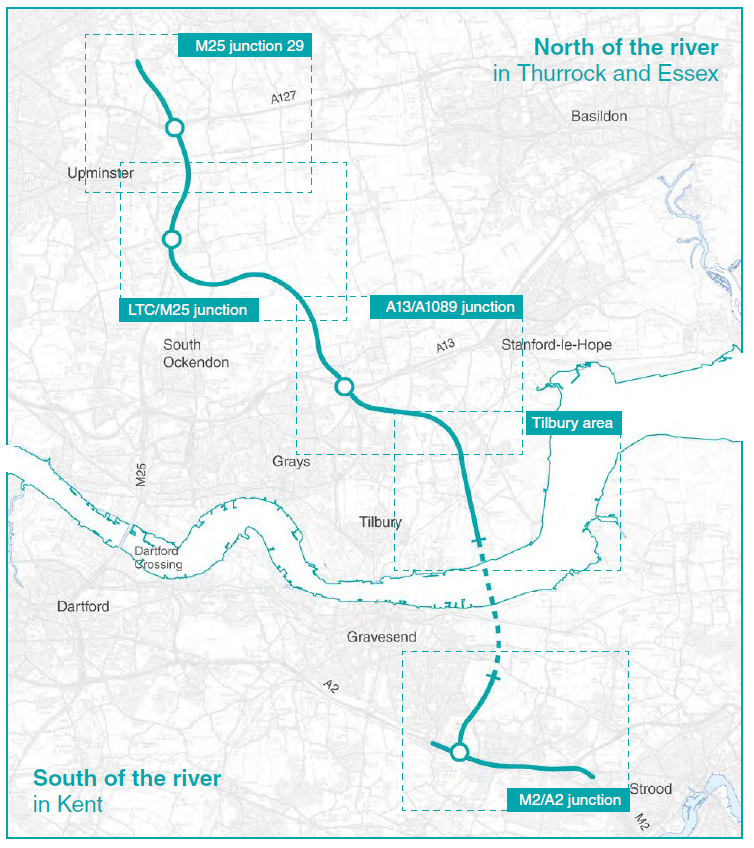
The route explained
For the purpose of describing the changes in more detail, we have divided the route into two sections:
- South of the river in Kent: M2/A2 junction and southern tunnel entrance.
- North of the river in Thurrock and Essex: Northern tunnel entrance, Tilbury area, A13/A1089 junction, LTC/M25 junction and M25 junction 29.
First, we will describe our proposals south of the river, then work our way north of the river.
Continue to the next section: Section 3a: Design refinements - South of the river in Kent
Read more
- Section 1: Foreword
- Section 2: Project updates
- Section 3: Design refinements
- Section 3a: Design refinements - South of the river in Kent
- Section 3b: Design refinements - North of the river in Thurrock and Essex
- Section 4: Property and landowners
- Section 5: Environmental impacts
- Section 6: How to have your say
- Section 7: Find out more
Audiences
- Anyone from any background
Interests
- Roads