
Lower Thames Crossing Design Refinement Consultation - Property and landowners
Overview
- Section 1: Foreword
- Section 2: Project updates
- Section 3: Design refinements
- Section 3a: Design refinements - South of the river in Kent
- Section 3b: Design refinements - North of the river in Thurrock and Essex
- Section 4: Property and landowners
- Section 5: Environmental impacts
- Section 6: How to have your say
- Section 7: Find out more
Property and landowners
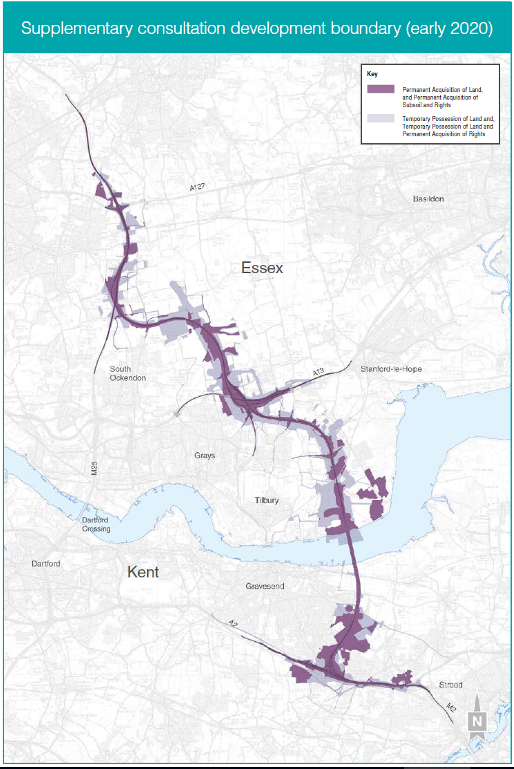
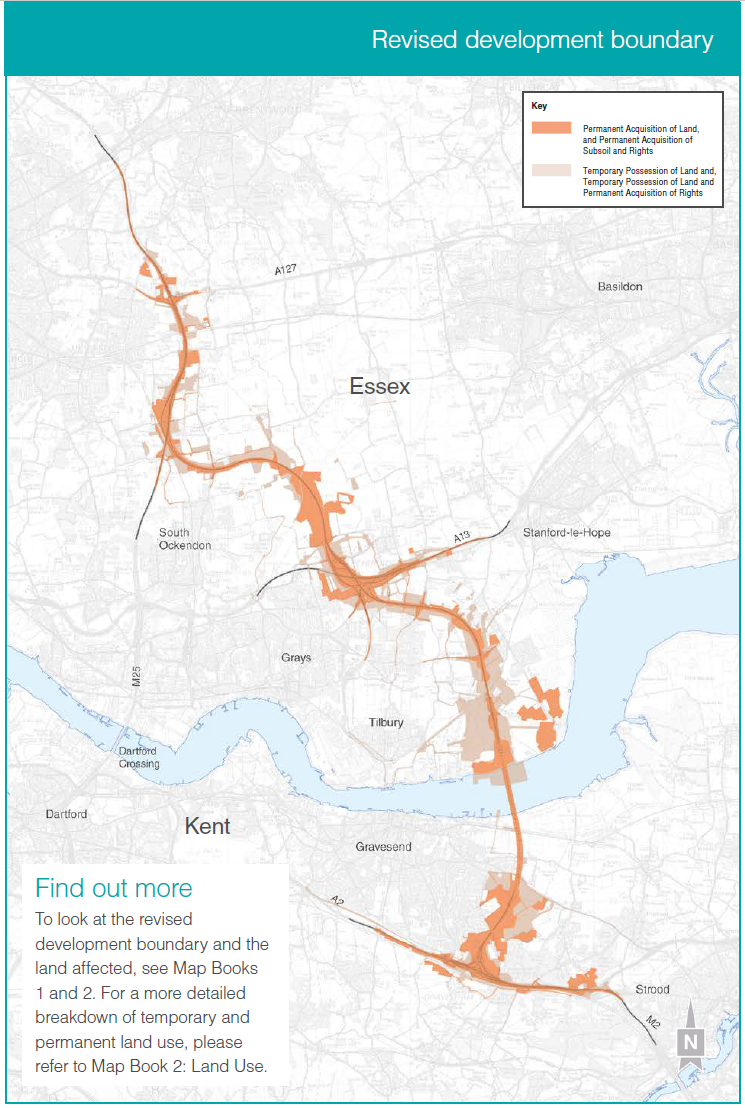
We have revised our development boundary to reflect the changes that we are now proposing for this design refinement consultation.
At supplementary consultation, the development boundary comprised over 26km² of land. Allowing for the changes we are now consulting on, the land within the revised development boundary is now slightly below 23km². We have been able to reduce this area by refining the design of utility diversions in some areas along the route.
A comparison of the development boundary presented at supplementary consultation, and the revised boundary, is shown on the following pages. Within this revised development boundary, there is now some additional land along the Lower Thames Crossing route that would be required permanently.
There are approximately 150 residential and business properties within the revised development boundary. This has been reduced from approximately 270 properties presented at supplementary consultation. Around 70 would only be affected by works to adjust existing electricity cables above the properties, so would not need to be purchased for the project. At supplementary consultation, this figure was around 190. Of the other 80 properties, around 40 would require demolition and the remainder would be impacted by construction works or would need changes to how they are accessed.
Did you know?
Special category land includes, but is not limited to, land that forms part of common and open space. The compulsory purchase of this land, or of rights over this land, such as a right of access, is subject to specific rules. The Lower Thames Crossing would have an impact on special category land including common land and open space.
Compulsory purchase is the acquisition of land or rights compulsorily, a power that we would seek in our DCO application.
Open space land can include public gardens, land used for public recreation and disused burial grounds.
Common land is private land with rights that allow the public to access and freely roam over it unless an exception applies.
We want everyone who lives in, or owns, land or property in the revised development boundary to have the opportunity to understand our proposals. We have a dedicated land and property team who are active in the community and are happy to discuss with any landowner their concerns and explain any rights they may have. See our ‘Find out more’ section to get in touch.
At the time we submit our DCO application, the revised development boundary will be referred to as the Order Limits.
Utility diversions
Where we are diverting utilities, such as power lines or gas pipelines, we would normally use the land temporarily but retain permanent rights over it to allow the utility owner to operate and maintain the utility infrastructure. This would allow ownership of the land to remain with the existing landowner. Other areas, for example construction sites, would also only be needed temporarily. When work is complete, any land would be reinstated and returned to its owner.
Special category land
In some locations, the Lower Thames Crossing is impacting existing areas of special category land.
Due to this, our revised development boundary includes replacement land for some of the special category land, or rights over land, that we propose to compulsory purchase.
In some cases, in accordance with the Planning Act 2008, replacement land has not been included. This is because, for example, the use of this land would be temporary, or because we are only proposing to divert utilities through the land. This means that its previous use can continue once our works are finished.
Where replacement land is being provided for any special category land, or rights over this land, it would be no less advantageous and of at least the same size.
Any replacement land has been indicated within Map Book 1: General Arrangements, and a breakdown of temporary and permanent land use can be found in Map Book 2: Land Use Plans.
In the tables below, we have set out our current understanding of the special category land that would be directly impacted by the project. This land would be subject to compulsory purchase, either of the land itself or rights over the land, or would be subject to temporary possession to construct the project.
For each site, we describe the special category land, the impact that the project would have on it and our proposals.
M2/A2
| Section of the route | Land description | Impact on the land | Lower Thames Crossing proposals |
| M2/A2 junction | Shorne Woods Country Park and Ashenbank Wood – The current use of the site is for recreational purposes and consists of woodland, walking tracks and educational walks. | We propose to permanently acquire land for the realignment of Thong Lane and the new road north of the A2. Permanent rights would also be required for the diversion of a gas pipeline, which may limit public use of the area. | We propose acquiring replacement land for the affected area to the east of Brewers Wood, part of Shorne Woods Country Park. The area would be designed to complement the existing site. We propose to include woodland planting and a footpath would be located through the replacement land. |
| M2/A2 junction | Jeskyns Community Woodland – The site is used for outdoor recreation, walking and cycling. | We propose using an area within the site for restringing existing overhead electricity distribution cables. | The use of the site is temporary and the land would be reinstated once the works are complete |
| M2/A2 junction | Cyclopark – The site in Gravesend includes walking and cycling facilities. | We propose to place an underground power supply through the site. | The use of the site is temporary and the land would be reinstated once the works are complete. Permanent rights would be required in relation to the underground power supply, however the use of land as open space would be unaffected. |
| M2/A2 junction | Shorne Marshes – The site is a grazing marsh. | The Lower Thames Crossing tunnel passes underneath the site but there would be no surface works. | There would be restrictions on the land to protect the tunnel, but the current use of the land on the surface would be unaffected. |
| M2/A2 junction | North-east of the M2/A2 junction, at the eastern end of Park Pale – The site is an open field with a footpath. | We propose to use this site for ancient woodland compensation. | Once these environmental mitigation works are complete, the site would be open to the public. |
| M2/A2 junction | Michael Gardens play area, Gravesend – This site is a play space within a public park. | We propose to upgrade a footpath running through the site, to connect with other footpaths across the project area. | Once the upgrade works are complete, the path and play area would remain open to the public. |
Tilbury Area
| Section of the route | Land description | Impact on the land | Lower Thames Crossing proposals |
| Tilbury area | Tilbury Green – This area of land is designated as common land and allows the public to freely roam over it. This land includes footpath 200 and links into other footpaths within the surrounding area. | We propose to permanently acquire part of footpath 200 for the new road and landscaping. This would remove the ability to freely roam over the affected section of the footpath. | We propose an alternative route for the footpath. The land on which this lies would be designated as common land. It would have the same rights as the affected part of the footpath. |
| Tilbury area | West Tilbury Marshes – Part of this area of land is designated as common land and provides marsh and scrub habitat, which is valuable for wildlife. | We propose to acquire permanent rights over the land for the utility works required for the northern tunnel entrance. The land would be used for temporary access and construction purposes. | The use of the site is temporary, and as the permanent rights would relate to underground equipment, the land would be returned to its current use when the works are complete. |
| Tilbury area | Walton Common and Parsonage Common – The land is designated as common land and provides scrub and grassland habitat, which is valuable for wildlife, and drainage. | We propose to acquire permanent rights over the land for the utility works required for the northern tunnel entrance. The land would be used for temporary access and construction purposes. | The use of the site is temporary, and as the permanent rights would relate to underground equipment, the land would be returned to its current use when the works are complete. |
A13
| Section of the route | Land description | Impact on the land | Lower Thames Crossing proposals |
| A13/A1089 junction | Ron Evans Memorial Field – The Ron Evans Memorial Field is located beside the A13/A1089 junction and is used by dog walkers and cyclists. | We propose to permanently acquire part of the site for a new section of road and landscaping. | We propose to acquire an area of replacement land next to the existing site. The replacement site would be landscaped and connected to the existing site. |
A13/A1089
| Section of the route | Land description | Impact on the land | Lower Thames Crossing proposals |
| North-west of A13/ A1089 junction | Grangewaters Outdoor Education Centre – The affected area is a car park. | We propose to use the car park for temporary works to make utility connections. | The use of the site is temporary and the land would be reinstated following completion of the works. |
LTC/M25
| Section of the route | Land description | Impact on the land | Lower Thames Crossing proposals |
| LTC/M25 junction | Orsett Fen – This area of land is designated as common land that is not accessible to the public as an exception applies. It provides agricultural rights to certain parties (common rights holders). | acquire land for the new road through the Mardkye. Land is also required permanently for the provision of environmental mitigation. This would affect the agricultural rights of the common rights holders. | We propose to remove the common land designation from the affected area of Orsett Fen and instead acquire and designate replacement land to the north and south of the existing site as common land. This land would have the same common rights and exceptions attached to it. |
| LTC/M25 junction | Thames Chase Forest Centre – The site consists of open fields, walking tracks and a mix of vegetation including memorial trees. | We propose to permanently acquire part of the site for the new road and earthworks. Permanent rights would also be required for the diversion of utilities. | We propose to acquire replacement land to the north and south of the Thames Chase Forest Centre. This would be landscaped to match the current site and would connect to the existing paths. The replacement land would be designed to complement the existing forest. As part of the mitigation, we propose a footbridge over the M25 to improve the connection between the western and eastern sections of the Thames Chase Community Forest. |
M25 junction 29
| Section of the route | Land description | Impact on the land | Lower Thames Crossing proposals |
| M25 junction 29 | Folkes Lane Woodland – The site consists of open fields, walking tracks and a mix of vegetation. | We propose to permanently acquire rights for the diversion of a gas pipeline, which may limit public use of the area. | We propose replacement land adjacent to the existing woodland, with landscaping to match the existing site and use, and to allow the spaces to link together. |
Sports clubs and Orsett Showground
In addition to impacting special category land, the Lower Thames Crossing would also impact a number of sports clubs, as well as the Orsett Showground site. This is either because we propose purchasing all or part of those sites (or rights over those sites) or taking temporary possession of them to build the project. Our proposals for each site are described in the table below.
| Section of the route | Description of the impact on the land |
| M2/A2 junction | Southern Valley Golf Club The site consists of a private members golf club. We propose to permanently acquire the site for the Lower Thames Crossing route and for landscaping. We are not proposing to replace the golf club. Instead we propose to create a new parkland area on part of the site, which would be accessible to the public following construction. |
| M2/A2 junction | Gravesend Golf Centre The site consists of a nine-hole pitch and putt golf facility with a driving range. We propose to permanently acquire part of the Centre, the pitch and putt, for the landscaped parkland area around the southern tunnel entrance. We would provide an alternative site to the south-east of the Cascades Leisure Centre, currently part of the Southern Valley Golf Club site, enabling the Gravesend Golf Centre business to continue. |
| A13/A1089 junction | Orsett Showground site Part of this site is required permanently for the construction of link roads to the Orsett Cock roundabout and the A13. We propose to move a gas pipeline and permanent rights would be required over a limited corridor of land within this site, to operate and maintain the gas pipeline. A replacement site for part of the Orsett Showground has been proposed within the development boundary. It is adjacent to the existing showground and is shown within Map Book 1: General Arrangements. |
| A13/A1089 junction | Orsett Royals Football Club The site includes a number of football pitches. We propose to move a gas pipeline and permanent rights would be required over a limited corridor of land within this site, to operate and maintain the gas pipeline. |
| A13/A1089 junction | Orsett Golf Club Part of this site would be used for construction and for diversion of a gas pipeline, but Orsett Golf Club would remain open during construction and the impact would be kept to a minimum. Permanent rights would be required over a limited corridor of land within this site, to operate and maintain the gas pipeline. |
| A13/A1089 junction | Thurrock Rugby Football Club Part of this site would be used for the diversion of overhead electricity transmission cables, but we do not expect these works to impact the use of the rugby club. Permanent rights would be required over this site for the operation and maintenance of those utilities. |
| LTC/M25 junction | Top Meadow Golf Club Part of this site would be used for restringing of the existing overhead electricity transmission cables for a limited period. Permanent rights would be required over this site for the operation and maintenance of those cables. We do not expect these works to significantly impact the use of the golf club. |
Have your say
To comment on the revised development boundary, answer questions 2a and 2b in the response form. To comment on our proposals for special category land and sports clubs, answer questions 2c and 2d.
More information
To see the revised development boundary and the land affected, please refer to Map Books 1 and 2. For a more detailed breakdown of temporary and permanent land use, please refer to Map Book 2: Land Use Plans.
Information about the Statutory Blight process and when compensation may be available can be found in the Highways England publications listed below. To access them, go to https://highwaysengland.co.uk/lower-thames-crossing-communities. If you are not able to view them online, get in touch using the contact details in the ‘Find out more’ section of this site and we will send you the information.
Your Property and Blight
Information for property owners within the development boundary.
Your Property and Discretionary
Purchase Information for those who live outside the development boundary but may need to sell their property.
Your Property and Compulsory Purchase
Information about the process we follow to purchase land and property needed for our schemes using compulsory powers and the compensation that may be available to people with an interest in that land or property.
Development boundary
Continue to the next section: Section 5: Environmental impacts
Read more
- Section 1: Foreword
- Section 2: Project updates
- Section 3: Design refinements
- Section 3a: Design refinements - South of the river in Kent
- Section 3b: Design refinements - North of the river in Thurrock and Essex
- Section 4: Property and landowners
- Section 5: Environmental impacts
- Section 6: How to have your say
- Section 7: Find out more
Audiences
- Anyone from any background
Interests
- Roads