
A66 Trans-Pennine Supplementary Design Consultation: walking, cycling and horse-riding provision, landform and compounds
Overview
Investing in your roads
At National Highways, we believe in a connected country where our network makes these connections happen. Our roads link with railway stations, ports and airports to give people a choice of travel and to support interconnectivity. When it comes to getting people where they need to be, we provide three times more miles per person than the railways.
We operate, maintain and improve England’s motorways and major A-roads and our network totals around 4,300 miles. While this represents only 2% of all roads in England by length, these roads carry a third of all traffic by mileage and two-thirds of all heavy goods traffic.
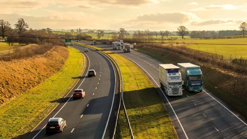
Our road network forms the economic back bone of the country, is open 24 hours a day, seven days a week and is relied on by communities and businesses to get from A to B.
Our 1,200-mile network across the north of England stretches from big cities like Manchester and Newcastle to the rural, single carriageways of Cumbria and Northumberland. It is one of the most diverse areas of motorways and major A-roads in the country to maintain and keep moving, so that we all get home safely. We also support local tourism, connecting the millions of holidaymakers who travel across the country to visit hotspots like the Lake District and Yorkshire Dales every year.
A66 Northern Trans-Pennine project
The planned improvement of the A66 plays a major part in our £27.4bn Roads Investment Strategy (RIS). It is the biggest investment in the north’s road network for a generation and is key to the Government’s Build Back Better and Northern Powerhouse plans, helping support local and regional growth. This huge investment will help level up the regional economic differences across parts of the UK.
The work we will deliver through this project will bring far-reaching benefits to those that use and live near the route. It will provide improved connections between Cumbria, Tees Valley and Tyne and Wear, but also routes between Scotland and the major towns and cities across the north. Critical national freight journeys will also be made more reliable. By providing better links, we will unlock access to tourism, jobs, essential services and new opportunities.
There are important choices to be made before the plans are submitted to the Planning Inspectorate in the form of an application fora Development Consent Order and a decision is reached by the Secretary of State for Transport. It is vital we listen to feedback from the people that live and work in the area and incorporate this into further design work.
Walking, cycling and horseriding provision, landform and compounds
We are committed to working closely with local communities to provide safe crossing points for walkers, cyclists and horse riders (WCH). Where the new A66 impacts an existing walking, cycling or horse riding rights of way, these will be diverted to the nearest safe crossing point. This may be a new junction, underpass or standalone bridge.
Since our preliminary design consultation in autumn 2021, we have moved some of our compound locations, made some changes to the landscaped bunds (artificial hills) and improvements to the walking, cycling and horse-riding provision on three schemes.
We are particularly keen to understand user journeys and issues faced when using rights of way around the A66. We will continue to engage with stakeholders to identify opportunities to improve provision for walkers, cyclists and horse riders and, where these are outside the scope of the project, we will explore alternative ways to support these objectives.
What we are proposing
Walking, Cycling and Horseriding provision
With its location in rural Cumbria, North Yorkshire, and Durham, the A66 attracts a high number of leisure walking, cycling and horseriding (WCH) users, especially during the summer. Local residents also make regular use of the footpaths around the existing single carriageway sections for exercise, dog-walking and social activities.
Our proposals for WCH were set out in our consultation in autumn 2021. They included details on how we would bring all WCH routes which intersect with the A66 to safe crossing points and junctions. In some cases, these routes would involve small diversions.
In our autumn 2021 consultation we did not include any provision for additional WCH routes along the new road corridor as this was outside the scope of the project. However, we received a lot of feedback about WCH during the consultation from stakeholders and local people. We have since been working with local authorities and landowners to introduce additional, specifically east / west, WCH routes where possible as part of the project.
We have already outlined our plans to reconnect WCH facilities severed by the dualling works at either grade-separated junctions or at stand-alone bridges and underpasses. We have also outlined plans to use the ‘old’ A66 on the section past Kirkby Thore and Crackenthorpe.
This supplementary consultation material intends to outline where there is new provision for east-west WCH routes introduced after our autumn consultation and to get your views on our plans.
Our new proposals in more detail
The following information outlines where we have introduced new WCH provision along the new road corridor and we welcome your thoughts on this as part of our supplementary consultation.
Clarification Statement: 16 March 2022
The plans show the routes proposed at our autumn consultation and our newly proposed additional provision. The routes shown at our autumn consultation provided a mix of routes for use by walkers and/or cyclists and/or horse riders (not necessarily all three).
The newly proposed additional provision (February 2022) on our schemes between Penrith and Rokeby are for walking and cycling. The newly proposed additional provision on our scheme between Stephen Bank and Carkin Moor is primarily for walking and horse riding, although can be used by cyclists also.
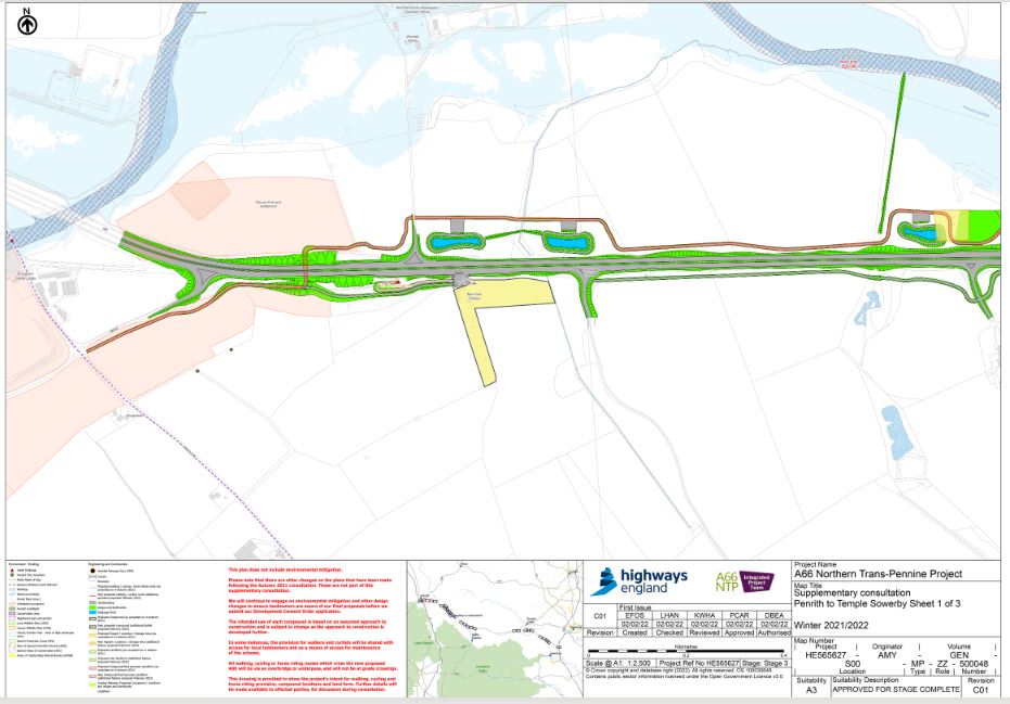
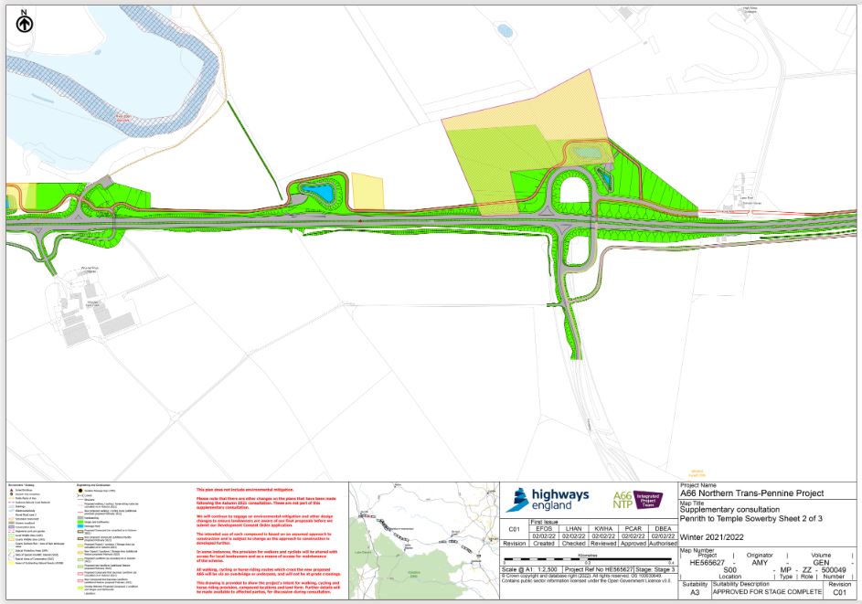
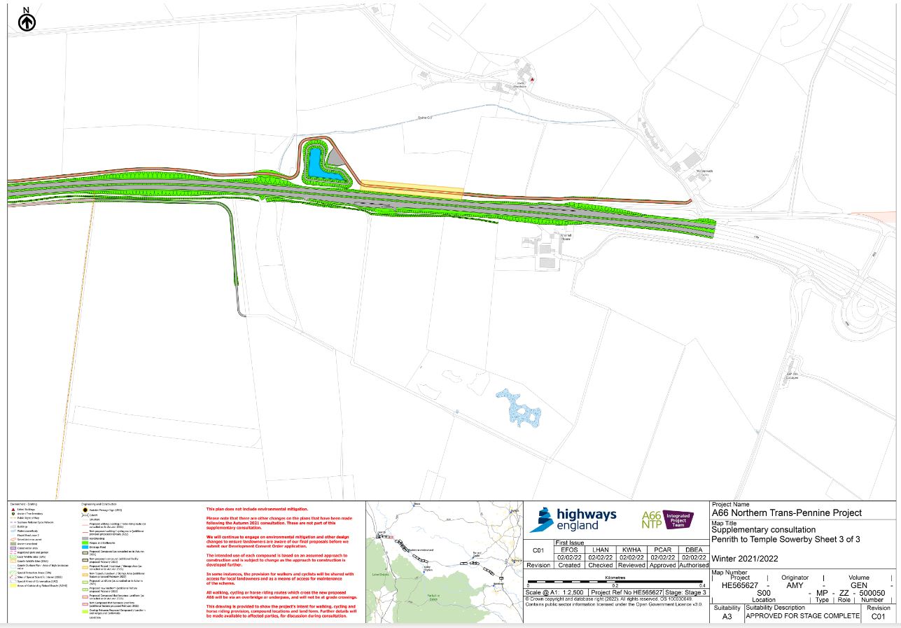
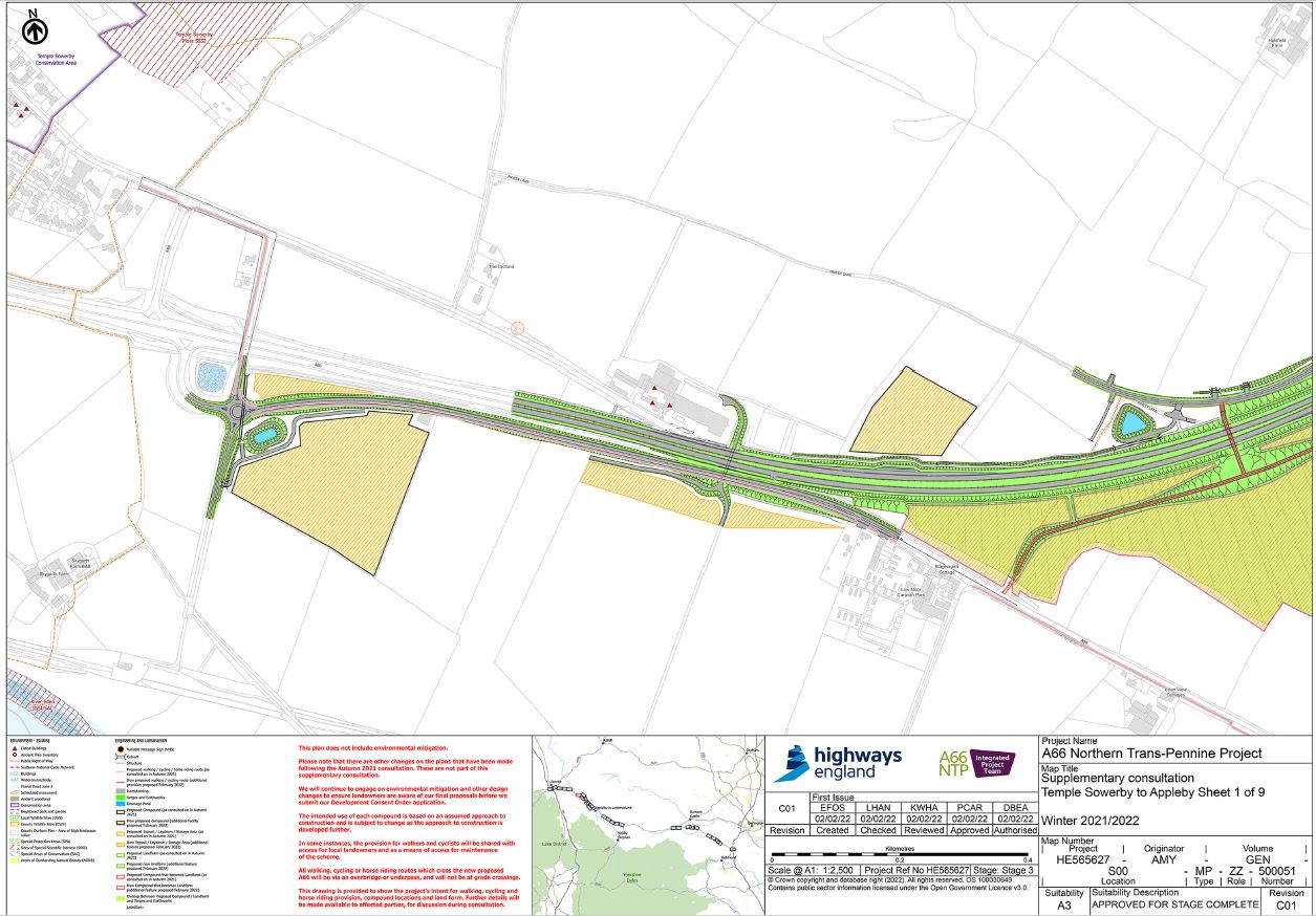
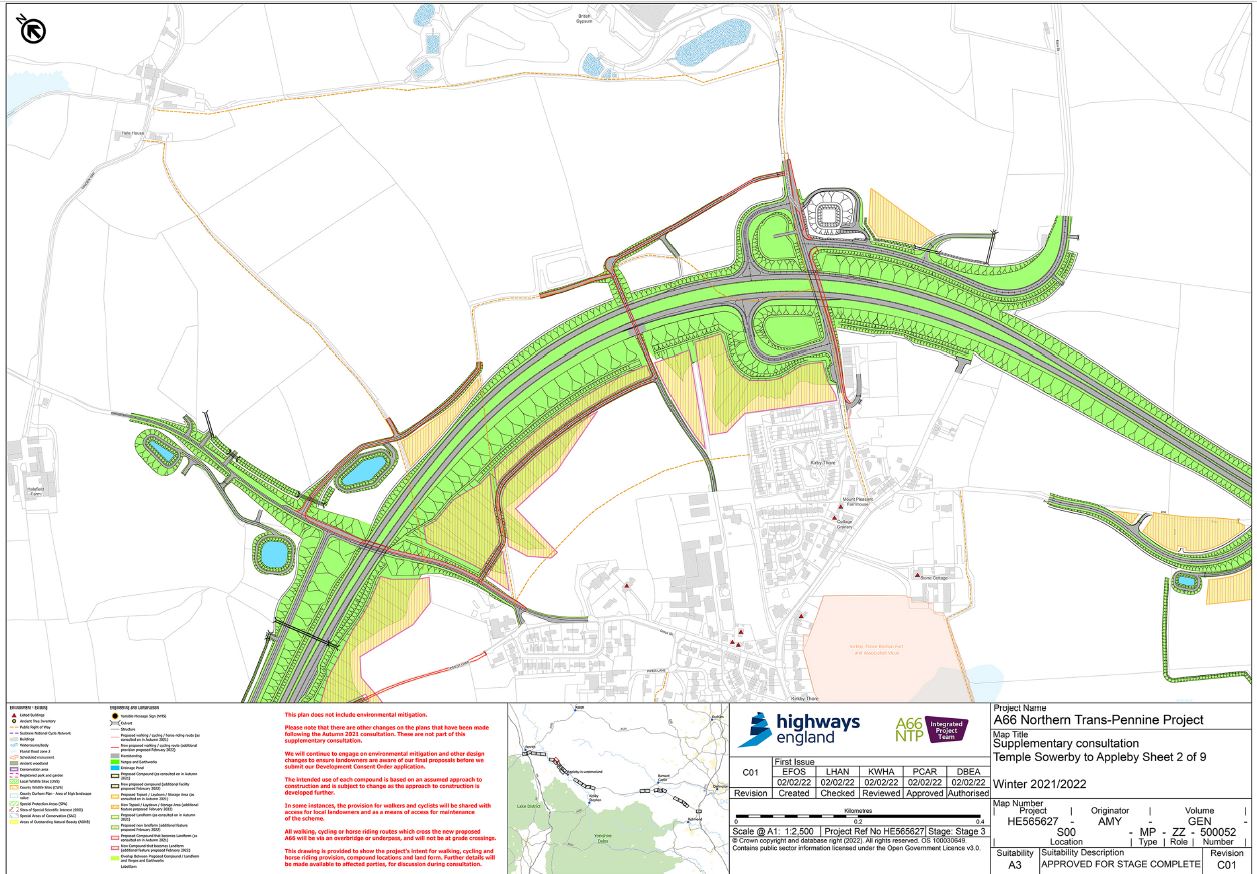
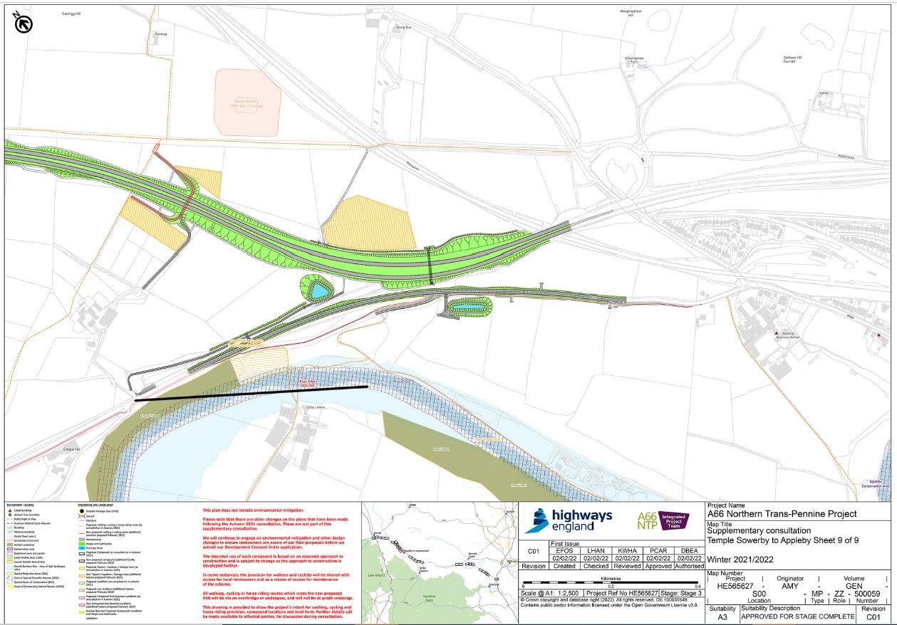
Penrith to Temple Sowerby
There was a lot of support at consultation for a continuous walking/cycleway in this area. We also recognised that closing the gap in the central reservation at the Brougham junction would negatively impact connectivity. In addition, an on-road cycle lane into Temple Sowerby would be lost due to the construction of the eastbound dual carriageway.
As a result, we have introduced proposals for a shared cycle/footway parallel to the A66. The route will tie into a grade-separated crossing at Brougham junction at the western extent and into existing infrastructure at the eastern extent at Temple Sowerby. The route will enable safe cycling and walking from Penrith to Temple Sowerby.
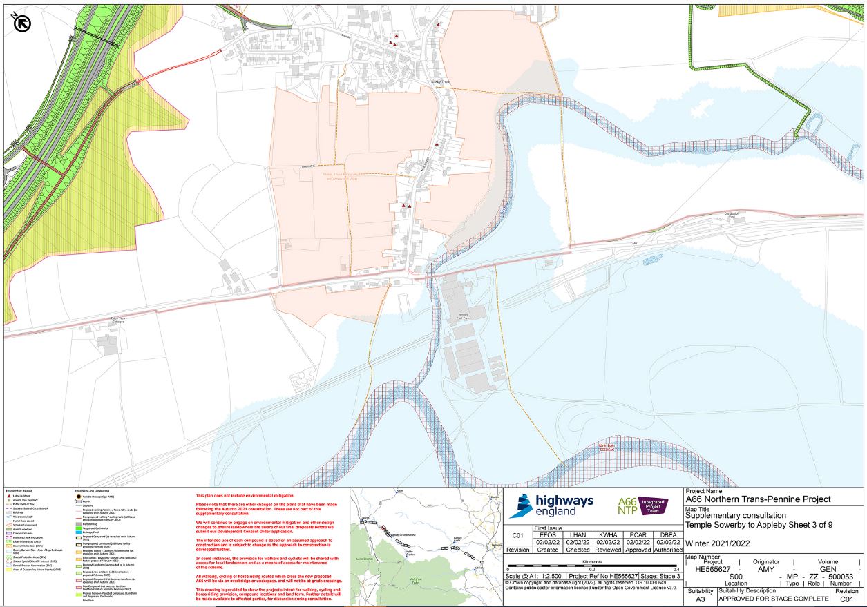
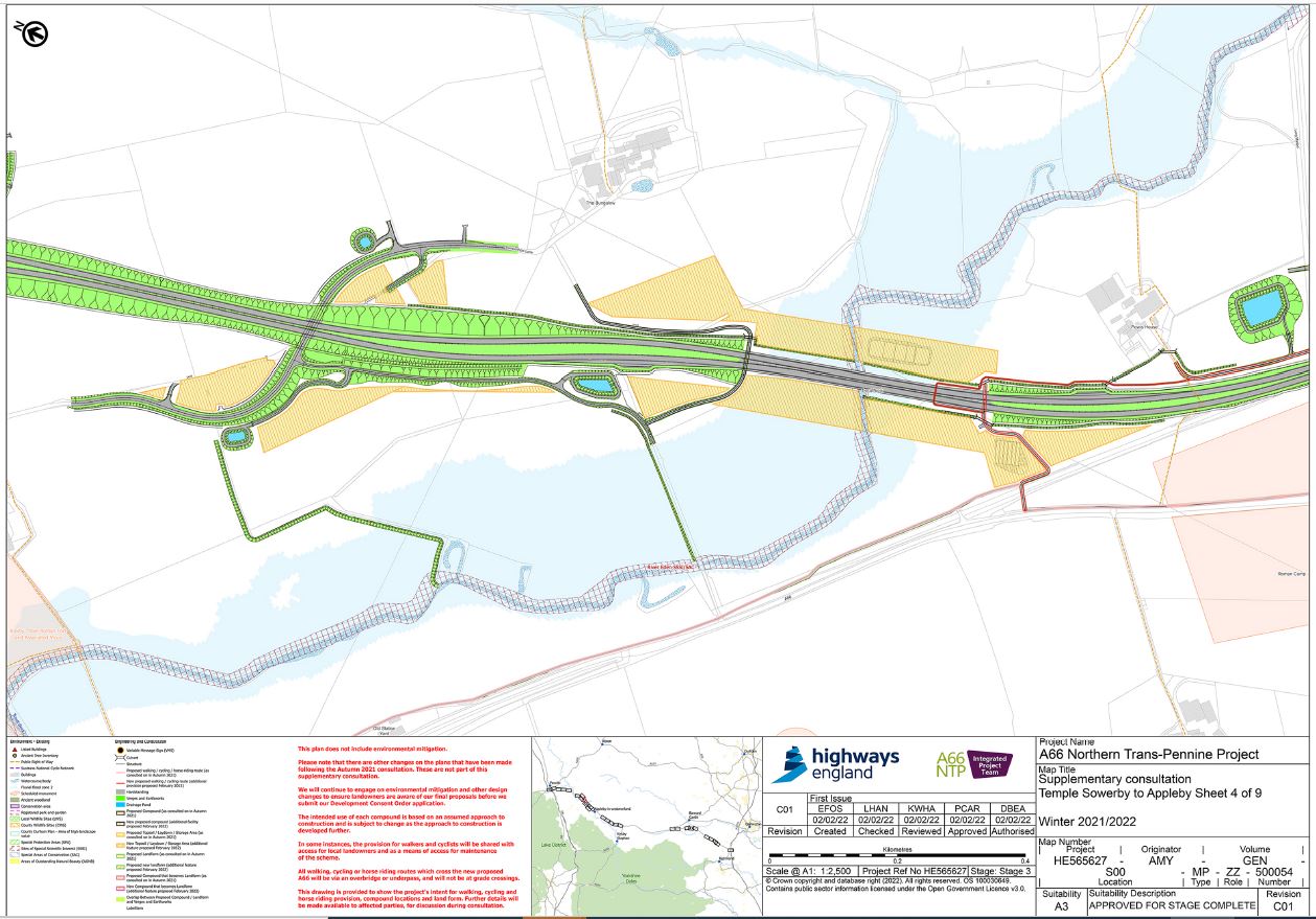
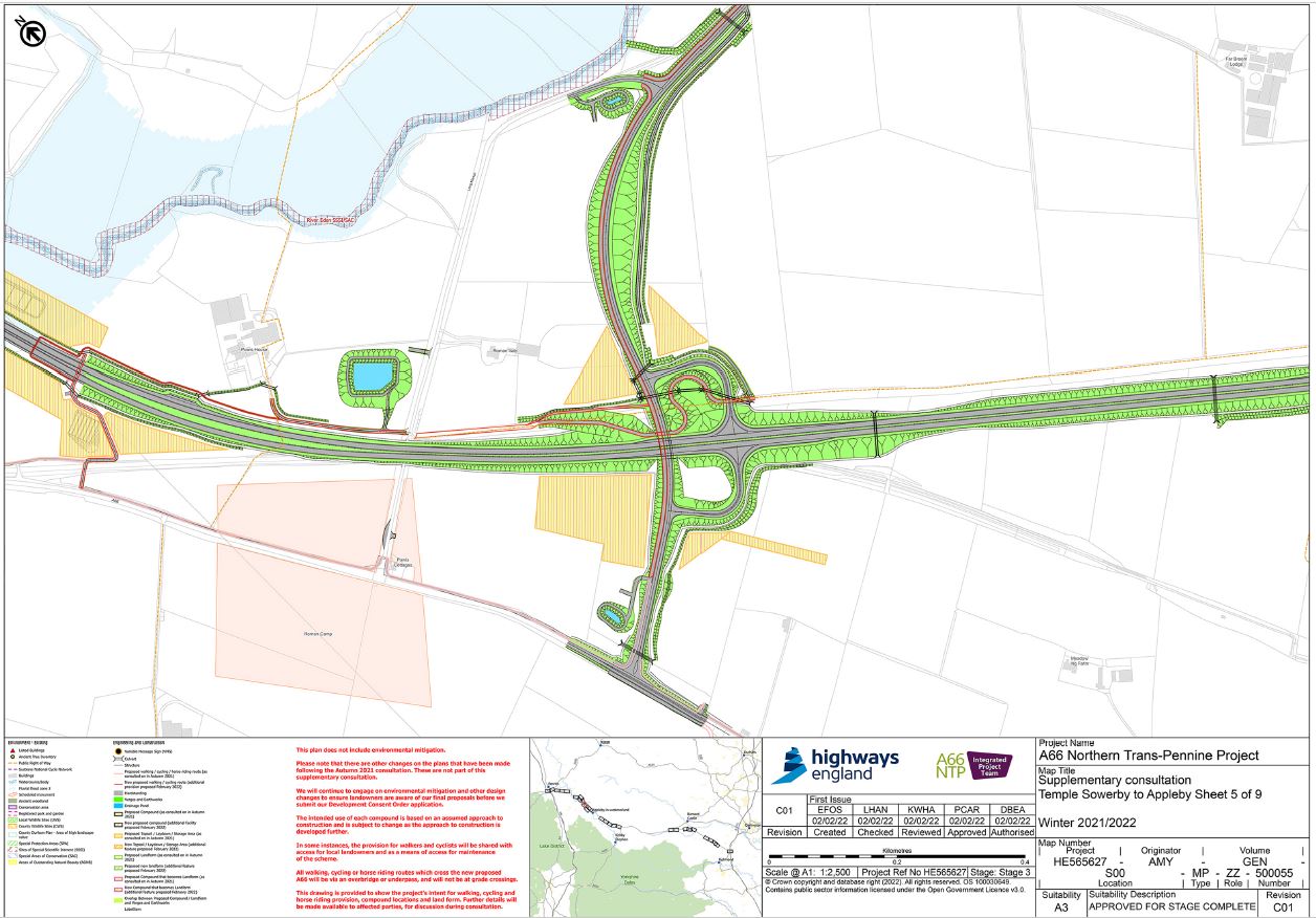
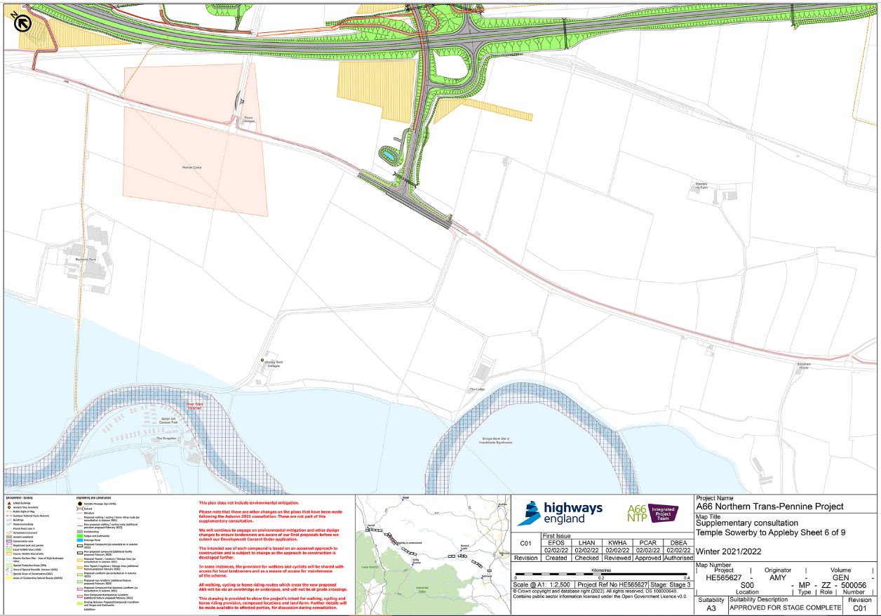
Temple Sowerby to Appleby
Plans to use the old A66 were included as part of the autumn consultation. However, we are re-consulting on this section as we are now providing further east-west connectivity on other sections of the route and we are interested in your feedback on this overall provision.
A shared cycle/footway is planned on the old A66 running the entire length of the scheme extent. This road will become a local route only, with significantly less traffic once the new dual carriageway is open. This route will run on the south side of the old A66 through Kirkby Thore, and then to the north to the west side of Appleby. This new route ties into existing provision at each end of the scheme. Segregated crossings of the proposed dual carriageway at several locations are proposed to reconnect and tie into rights of way.
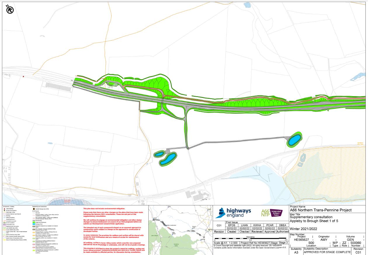
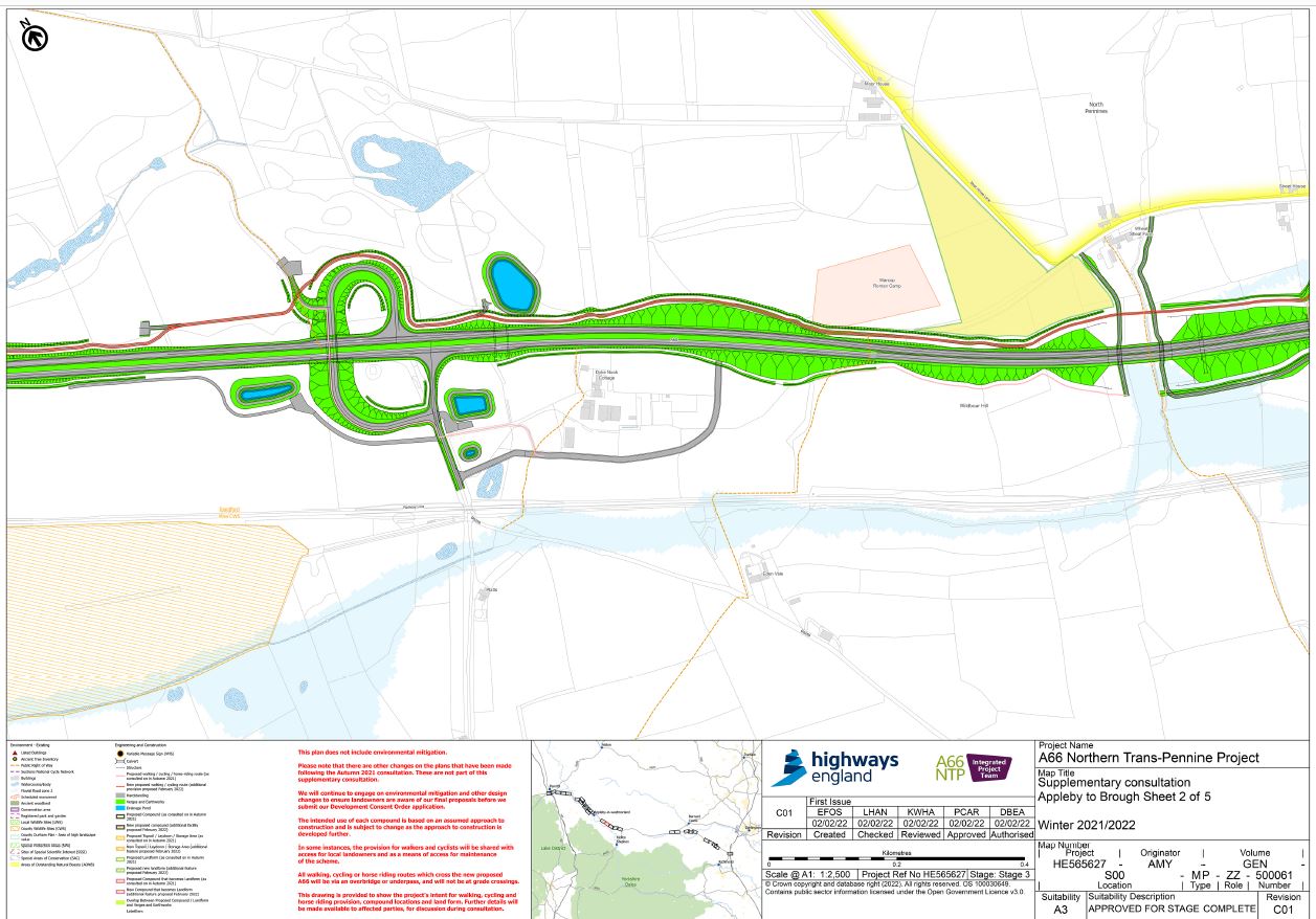
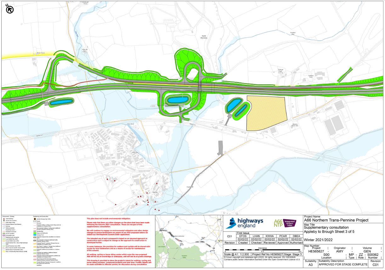
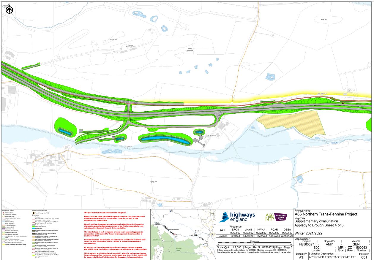
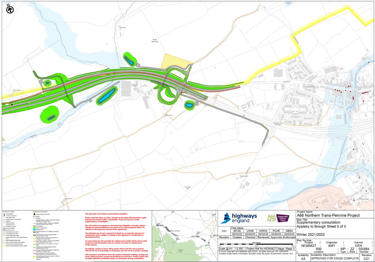
Appleby to Brough
We are proposing to introduce a shared-use cycle/footway parallel to the A66 which will connect into the existing rights of way in the vicinity of the scheme. It will utilise the grade-separated crossing points of the dual carriageway along the route.
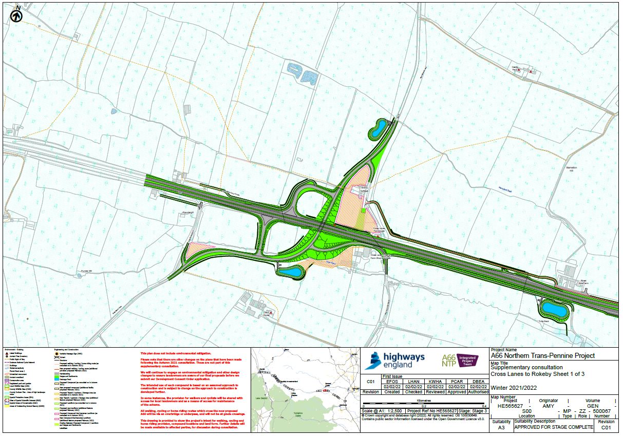
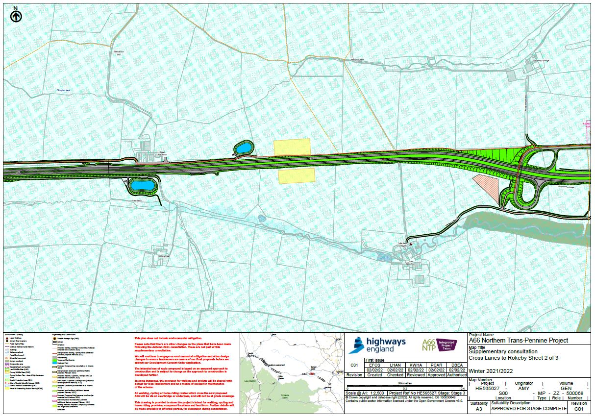
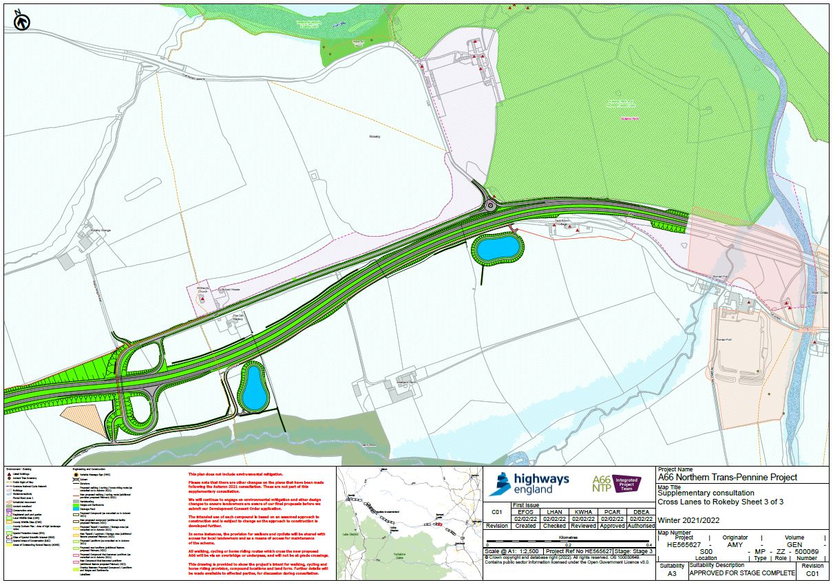
Cross Lanes to Rokeby
We are proposing to introduce a shared-use cycle/footway parallel to the A66 which will connect into existing rights of way to the west of the Rokeby Junction, using the proposed maintenance access track that leads to the junction at Cross Lanes. While the additional infrastructure is only 250m in length, the result is a 3.5km shared cycle/footway from Cross Lanes junction to Greta Bridge, tying into the exiting cycle track to the west of the village.
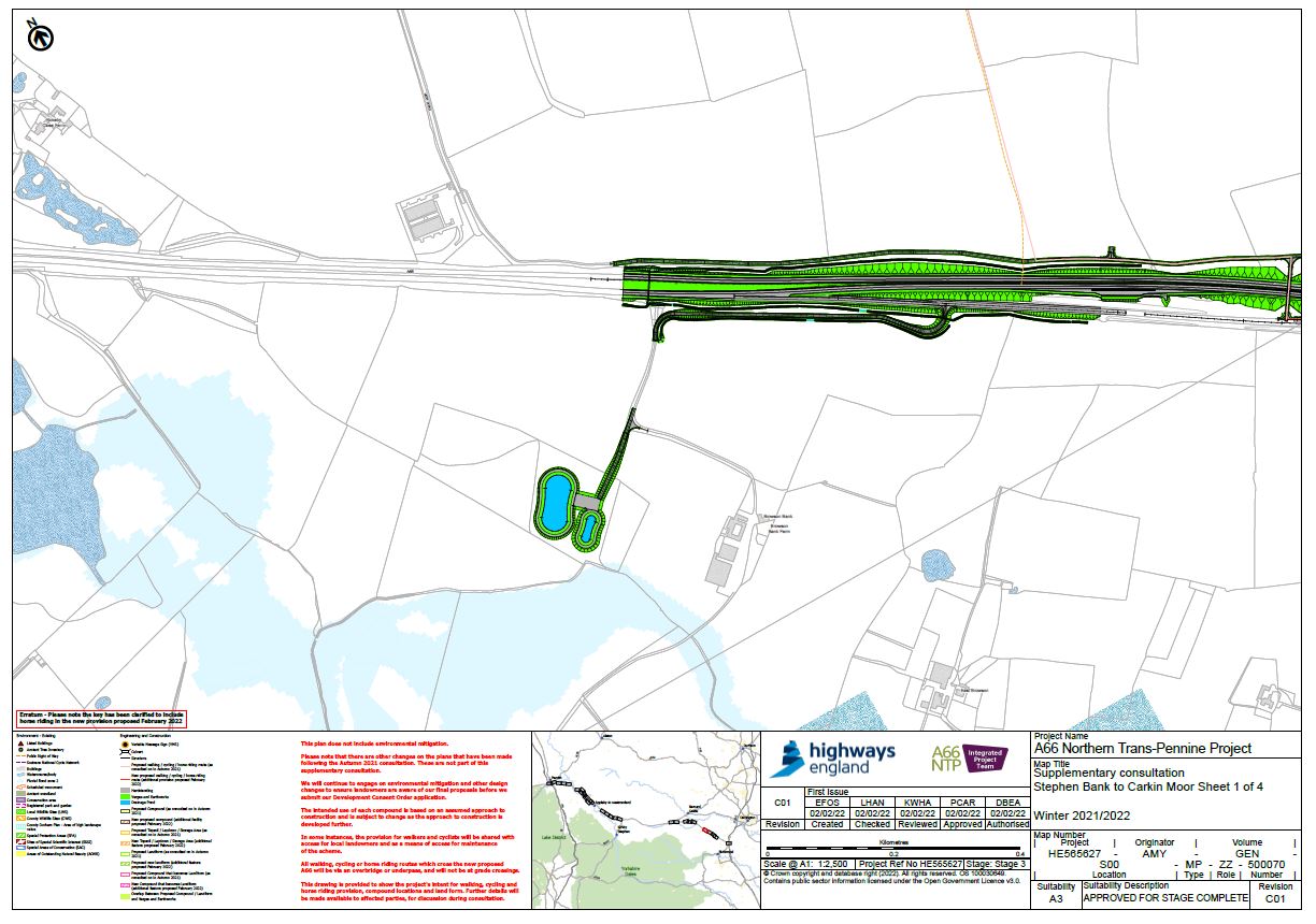
Stephen Bank to Carkin Moor: UPDATED 16 MARCH 2022
On this section, the feedback at consultation was more focussed around provision for horse-riders.
As a result of the consultation process, a shared bridle/footway has been proposed in the verge along the old de-trunked A66. This road will become a local route only, with significantly less traffic once the new dual carriageway is open. The new bridle/footway will connect several existing bridleways and footpaths in the area. It will allow circular routes and onward journeys by users, including grade separated crossings of the dual carriageway.
Where the new route crosses the old de-trunked A66, horse corrals will be provided.
Landform
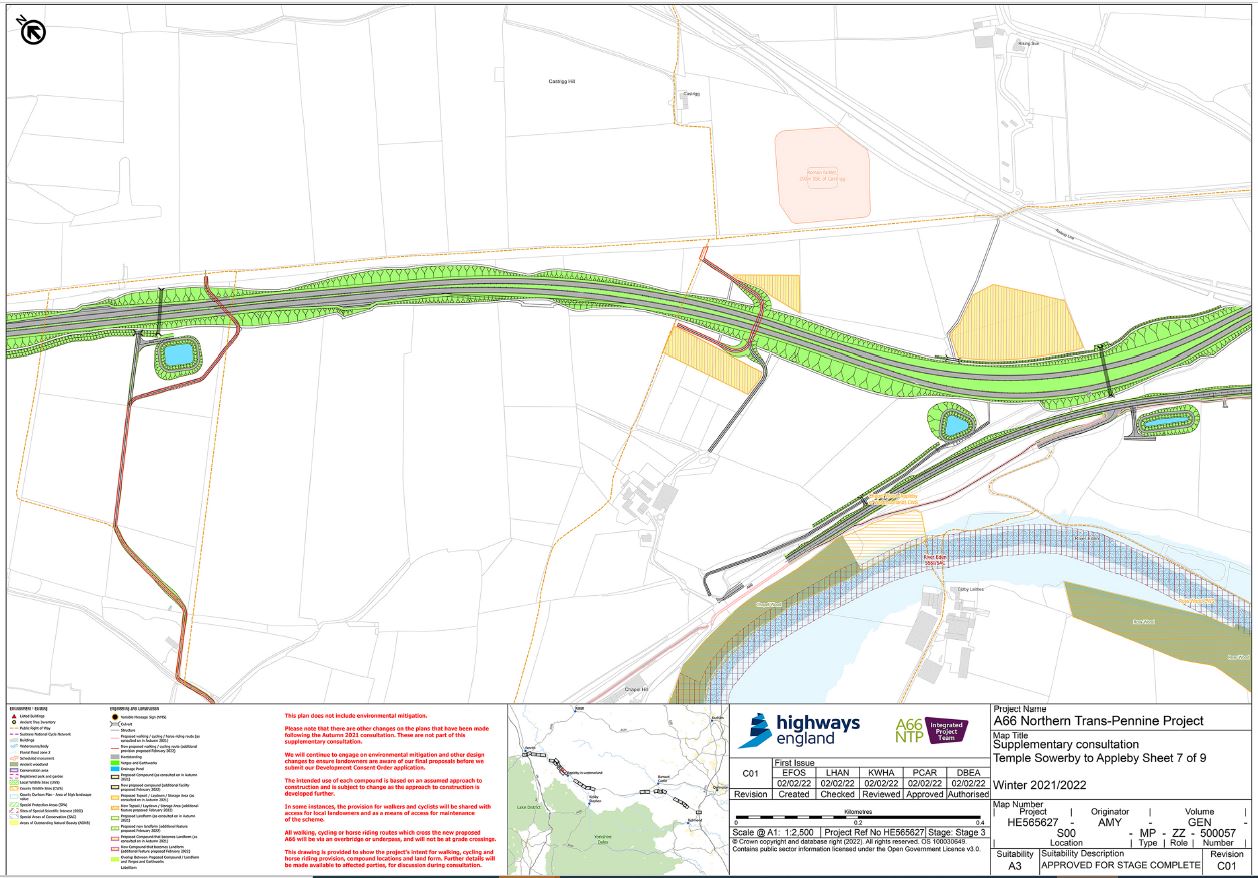
Since our autumn consultation we have made some proposed changes by introducing landscaped bunds – artificial hills – on certain sections of the route. By adding these landscaping features, we aim to minimise the impacts of the road on your community and on the character of the landscape.
Bunds serve a range of purposes. They allow us to screen off sections of the road; provide a sound barrier that reduces the noise of passing traffic.
Bunds are quite simple in their concept. Soil is shaped into a feature that blends into the local landscape to mask the road. To make it more attractive to the eye, trees and shrubs can be planted into the bund, which then help to remediate the soils contained within. Importantly, bunds offer a more flexible, visually “softer” option than other types of screening, such as fences and walls.
To make these changes, we will need to acquire land on a temporary basis, but our aim is to return land to landowners, where possible, once the bunds are created. Any new landform added since our autumn consultation are shown in yellow with a green outline on our maps.
We welcome your thoughts on this as part of our supplementary consultation.
Compounds
Should the project be approved, we will need to build a number of temporary work compounds and storage areas near to the route. These will be used for a variety of purposes, including offices for staff, welfare facilities, storage for plant machinery and materials. The size and shape of these compounds varies, as does the number of staff required, so we anticipate several large compounds supported by smaller, satellite sites. To support the sustainability of the project, we will explore how innovative technology solutions can be introduced, including solar powered offices and charge points for electric vehicles for use by construction staff.
The location of these compounds is very important and depends on the specific work planned for the area. Some facilities will need to be sited close to major structures and we will need to store large quantities of soil near to areas we plan to in-fill.
Our proposals for several compounds have moved location since our autumn consultation and it is possible their use will change as we move into the detailed design stage of the project. We know moving heavy plant machinery can potentially impact local traffic, so we have identified areas where our compounds can minimise any congestion.
Any compounds added since our autumn consultation are shown in yellow with a pink hatch on our maps. Those unchanged since consultation are shown in yellow with no hatch.
We welcome your thoughts on this as part of our supplementary consultation.
Compound changes have been made throughout each section of the route. Please check our route maps in the ‘Related Document’ section at the bottom of this page to view changes.
Access feedback form
Developed proposals
This project represents one of the largest and most important highways investments in the north of England in a generation. The A66 Northern Trans-Pennine project is classified as a Nationally Significant Infrastructure Project (NSIP) by the UK Government under the Planning Act 2008. As such, Highways England are required to make an application for a Development Consent Order to obtain permission to construct and operate the new A66.
Our consultation feedback form provides you with an opportunity to help us shape the proposals before we submit our Development Consent Order application.
For more supporting information, including Preliminary Environmental Information, Route Development Reports and Construction Methods from our earlier consultation in 2021, please click on the link below.
Access Supporting Information
Why your views matter
Road infrastructure improvements affect everyone. They help us move around our country and connect with one another. It’s essential that we understand your views, so we can ensure we deliver the right schemes.
Public consultation plays a vital part in the development of scheme design. Your feedback on this consultation will help us understand how the proposed options impact road users and the local community. You will be helping to shape the scheme and maximise the benefits as we progress the design.
Projects of this size and importance need a Development Consent Order (DCO). Before we can submit an application for a DCO, we consult with road users, the local community and other stakeholders on our proposals for the scheme.
Another chance to join the conversation
Further to our Preferred Route Announcement in 2020, and our Design Consultation in 2021, your views are really important to us, so we welcome your feedback on our proposals for compounds, landforms and WCH and have included contact details and a feedback form on this page.
We’ll be consulting with you between Wednesday 16 February and 20 March 2022. This will provide you with the opportunity to find out more about our proposals and have your say about them.
We will continue to engage with landowners and local authorities on issues such as maintenance and signage arrangements as we work though the detailed design stage. We’ll also continue to engage with stakeholders, our Community Liaison Groups and Focus Groups about these plans.
If you want to review hard copies of any technical documents, we can arrange a meeting with you to do so where members of the project team will be on hand to guide you through our proposals and answer your questions. To arrange a meeting or ask any questions about our proposals, you can call or email us to request a meeting by emailing us on: A66NTP@highwaysengland.co.uk or calling us on 0333 090 1192.
Development Consent
The A66 Northern Trans-Pennine project is classed as a Nationally Significant Infrastructure Project (NSIP) under the Planning Act 2008. This means that we are required to make an application for a Development Consent Order (DCO) to obtain permission to construct our proposed improvements.
Before we can submit an application for a DCO, we must formally consult the local community and other stakeholders on our proposals for the scheme and the likely significant environmental effects based on the information available at the time.
Following our preliminary design consultation, a development consent application will then be made to the Planning Inspectorate, who will examine our proposals. The examination process is likely to involve public hearings. Following the examination, the Planning Inspectorate will make a recommendation to the Secretary of State for Transport, who will decide whether the project will go ahead.
Our application for development consent will be made on the full route between M6 junction 40 to Kemplay Bank and A1(M) junction 53 Scotch Corner and we intend to submit our application for development consent in spring 2022. Subject to development approval, we expect to start construction in 2024.
To help us shape the final design in preparation of the submission to the Planning Inspectorate, your feedback will help us shape the proposals before we submit our DCO application so it is important you are involved now and submit your response by 11.59pm on 20 March 2022.
Further information on the DCO process can be found on the National Infrastructure Planning website and also in our animation video below:
What happens next
Once our public consultation closes we will take time to analyse and consider your views when making further refinements to the proposed design and to develop our planned mitigation measures. We will set out a summary of the responses and describe how the proposals have been informed by and influenced by them in a consultation report. This will form part of our application for development consent and will also be available to the public following submission of the application.
Subject to completing necessary development works, we anticipate submitting a DCO application in spring 2022 to the Planning Inspectorate, acting on behalf of the Secretary of State for Transport (SoS), who will examine the application and hold some public hearings, before making a recommendation to the SoS, who will decide on whether or not the proposed scheme will go ahead.
Related documents
A consultation brochure is available as part of this public consultation. In addition to the supporting information contained within this page, more supporting information, including Preliminary Environmental Information, Route Development Reports and Construction Methods can be accessed from our 2021 design consultation page by clicking on the link below.
Access Supporting Information
Please note that some documents are larger than others and may need additional time to download before they are fully visible. You can access user friendly versions of our preliminary design consultation materials by visting our 2021 Design Consultation page however if you experience any issues accessing any materials, require alternative formats of our consultation materials, additional copies, or require materials posting to you, please get in touch with our project team by emailing A66NTP@highwaysengland.co.uk or by calling 0333 090 1192.
Audiences
- All members of the public
Interests
- Roads
Share
Share on Twitter Share on Facebook