
A417 Missing Link Public Consultation - September 2019
Overview
IMPORTANT NOTICE: THIS PUBLIC CONSULTATION HAS NOW CLOSED.
Investing in your roads
The A417 Missing Link scheme is identified within the Government’s 2015-2020 Road Investment Strategy (RIS1), which states that England’s Strategic Road Network requires upgrading and improving to ensure it can deliver the performance needed to support the nation in the 21st century. The A417 is a critical part of this investment that aims to to improve journeys between Brockworth and Cowley, which will in turn benefit the local and regional economy.
Give Us Your Views
Our proposals
Over the next six weeks between 27 September and 8 November 2019 we are consulting further on our proposals to improve the A417 Missing Link, a single lane stretch of carriageway between the Brockworth bypass and Cowley roundabout in Gloucestershire.
A summary of our proposals is as follows:
- 3.6 miles (5.8 km) of new dual carriageway connecting the existing A417 Brockworth bypass with the existing A417 dual carriageway south of Cowley
- The section to the west of the existing Air Balloon roundabout would follow the existing A417 corridor. However, the section to the south and east of the Air Balloon roundabout would be offline, away from the existing road corridor
- A new junction at Shab Hill, providing a link from the A417 to the A436 towards Oxford and into Birdlip
- A green bridge near Crickley Hill
- A new junction would be included near Cowley, replacing the existing Cowley roundabout
The existing A417 between the Air Balloon roundabout and the Cowley roundabout would be repurposed. Some lengths of this existing road would be converted into a route for walkers, cyclists and horse riders. Other sections would be retained to maintain local access for residents.
All the documents related to this consultation can be found at the bottom of this page.
Share your views
We would like to hear your views about our proposals.
It is important that you submit your response by 11.59pm on Friday 8 November 2019. Responses received after this time may not be considered.
You can have your say on our proposals by using one of the following methods:
- Online – complete the consultation feedback questionnaire online by clicking the link below.
- Freepost – complete a copy of the consultation feedback questionnaire and send it to us at FREEPOST A417 MISSING LINK (the address must be written in capital letters and you do not need to use a stamp).
- In person – visit one of our public consultation events and hand a completed consultation feedback questionnaire to a member of staff.
- Email – send a copy of the completed consultation feedback questionnaire via email to: a417missinglink@highwaysengland.co.uk.
All the documents related to this consultation as well as a link to our online can be found at the bottom of this page.
You can access all our consultation documents at the bottom of this page, but paper copies are also available. Here’s how you can access them:
You can find the consultation booklet and feedback questionnaire at any of our deposit points or public information points.
You can also contact on our customer contact centre on 0300 123 5000 or email a417missinglink@highwaysengland.co.uk and we will send these to you free of charge.
You can view the Preliminary Environmental Information (PEI) Report, consultation plans and mainline plan and profile drawings at our deposit points, although these are not available to take away with you. If you would like to order these you can request them from our contact centre (see above for details) to arrange payment. These can incur a cost of up to £200 per document (including printing, postage and VAT); we will provide more details should you require a copy of any of these documents.
Public consultation events
One of the best ways to find out more about our proposals and have your say is to come to one of our public consultation events. Here you will be able to find out more about the scheme and speak to members of the project team who will be happy to answer any questions you may have.
| Date | Time | Address |
|---|---|---|
| Monday 30 September 2019 | 2pm to 8pm | Gloucester Rugby Club, Kingsholm Road, Gloucester, GL1 3AX |
| Thursday 3 October 2019 | 1pm to 8pm | National Star College, Ullenwood, GL53 9QU |
| Saturday 5 October 2019 | 11am to 6pm | Witcombe and Bentham Village Hall, Pillcroft Road, Witcombe, GL3 4TB |
| Monday 7 October 2019 | 11am to 6pm | St Andrews Church Hall, Montpellier Street, Cheltenham, GL50 1SP |
| Wednesday 9 October 2019 | 2pm to 8pm | Birdlip Church, Birdlip, GL4 8JH |
| Friday 11 October 2019 | 11am to 6pm | Cirencester Town Council, Bingham House, 1 Dyer Street, Cirencester, GL7 2PP |
| Tuesday 15 October 2019 | 2pm to 8pm | Churchdown Community Association, Parton Road, Churchdown, Gloucester, GL3 2JH |
Virtual consultation
Our public consultation events are by far the best way to gain an understanding of how the scheme will work, look and feel – but if you can’t get to an event, you can still explore our proposals with our virtual consultation, below. Use your cursor to explore all the different elements of the scheme, and get a flavour for how it will feel to drive along the new road on our scheme visualisation.
Virtual Consultation
Deposit points
Copies of all of the consultation documents are available to view in the following locations for the duration of the consultation period:
| Location | Opening times |
|---|---|
| Cotswold District Council main offices, Trinity Road, Cirencester, Gloucestershire, GL7 1PX | 9am – 5pm: Monday to Friday |
| Gloucestershire County Council, Shire Hall, Westgate Street, Gloucester, GL1 2TG | 8.30am – 5pm: Monday to Friday |
| Tewkesbury Town Hall, High Street, Tewkesbury, GL20 5AL |
10am – 3pm: Monday to Thursday |
Public information points
Our public consultation booklet and feedback questionnaire are also available to pick up at the following public information points:
| Location | Opening times |
|---|---|
| Brockworth Community Library, Moorfield Road, Brockworth, GL3 4ET | 10am - 1pm and 2pm - 5pm: Monday to Wednesday 2pm - 5pm: Thursday 10am – 12.30pm: Saturday |
| Cheltenham Library, Clarence Street, Cheltenham, GL50 3JT |
9am – 7pm: Monday to Friday 9am – 5.30pm: Tuesday and Thursday 9am – 4pm: Saturday |
| Churchdown Library, Parton Road, Gloucester, GL3 2AF |
10am – 1pm and 2pm – 6pm: Tuesday 10am – 1pm and 2pm – 5pm: Wednesday to Friday 10am – 1pm: Saturday |
| Cirencester Library, The Waterloo, Cirencester, GL7 2PZ |
9.30am – 5pm: Monday and Thursday 9.30am – 7pm: Tuesday and Friday 9.30am – 1pm: Wednesday 9.30am – 4pm: Saturday |
| Coleford Library, The Main Place, Old Station Way, Coleford, GL16 8RH |
10am – 2pm: Monday and Saturday 10am – 7pm: Tuesday 10am – 5pm: Wednesday to Friday |
| Crickley Hill Visitor Centre, Crickley Hill, Birdlip, Gloucester GL4 8JY |
8am – 5pm: Monday to Friday |
| Gloucester Library, Brunswick Road, Gloucester, GL1 1HT |
9am – 7pm: Monday, Tuesday and Thursday 9am – 5.30pm: Wednesday to Friday 9am – 4pm: Saturday |
| Hucclecote Library, Hucclecote Road, Gloucester, GL3 3RT |
9.30am - 12pm and 1pm - 4pm: Monday and Tuesday 9.30am - 12pm and 1pm - 5pm: Wednesday 2pm - 5pm: Thursday 9.30am - 12pm and 1pm - 7pm: Friday 10am - 4pm: Saturday |
| Moreton Area Centre, High Street, Moreton-in Marsh, Gloucestershire, GL56 0AZ |
8.45am – 5pm: Monday to Friday 10am – 1pm: Saturday (until end of October) |
| National Star College, Ullenwood, GL53 9QU |
8am – 9pm: Monday to Friday 8am – 6.30pm: Saturday |
| Stroud Library, Landsdown, Stroud, GL5 1BB |
9.30am – 6:30pm: Monday and Friday 9.30am – 5pm: Tuesday and Wednesday 9.30am – 2pm: Thursday 9.30am – 4pm: Saturday |
| Tewkesbury Library, Sun Street, Tewkesbury, GL20 5NX |
9.30am – 5pm: Monday and Friday 9.30am – 7pm: Tuesday and Thursday 9.30am – 1pm: Wednesday 9.30am – 4pm: Saturday |
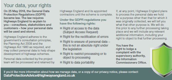
Data Protection and You:
General Data Protection Regulations
Why your views matter
Background to public consultation
In February - March 2018, we carried out a consultation on options to improve the A417 between Brockworth bypass and Cowley roundabout in Gloucestershire. This year we published our Preferred Route Announcement for the proposed A417 Missing Link, known as Option 30, We then began developing the design as part of our work towards submitting an application for consent from the Secretary of State for Transport.
What is Option 30?
Option 30 is a 3.6 mile surface route following the alignment of the existing A417 at Crickley Hill with less of a slope than the existing road. The new section of road would be built through Shab Hill to the east of the existing A417, re-joining the road near the existing location of Cowley roundabout.
To learn more about our preferred route, please see the documents below. For more information on the development of the project and to subscribe to regular updates, please visit the A417 Missing Link scheme webpage.
The need for the scheme
The A417 through the Cotswolds makes up one of the south west’s most important road corridors, helping people get to work and school and visit family and friends.
But there’s a problem. While most of the route is dual carriageway, there’s one section that isn’t. Known as the ‘Missing Link’, this three mile stretch of single carriageway on the A417 between the Brockworth bypass and Cowley roundabout restricts the flow of traffic, causing congestion and pollution.
Congestion can be so unpredictable that some motorists rat run along local roads, affecting the communities along these routes. These local roads were not designed for this level of traffic and collisions often happen.
The existing A417 runs through the Cotswolds Area of Outstanding Natural Beauty, and crosses the highly sensitive Cotswolds escarpment at Crickley Hill. The challenging shape of the landscape, and the highly sensitive nature of the Cotswold escarpment, means that there is no easy solution for improving this section of road.
Over the years, there have been numerous attempts to improve the A417 Missing Link. For various reasons, including affordability and changes in investment priorities, these have never come to fruition. However, in recent years, the case for improvement has become more compelling – to improve safety, support the economy, ease congestion and reduce pollution.
In recognition of this, the Government’s Road Investment Strategy sets out the intention to improve the A417 Missing Link between the Brockworth bypass and Cowley roundabout.
Overview of the proposed scheme
Our proposed scheme comprises 3.6 miles (5.8 km) of new dual carriageway connecting the existing A417 Brockworth bypass with the existing A417 dual carriageway south of Cowley, key features include:
Climbing the escarpment
A section of road to the west of the existing Air Balloon roundabout which follows the existing A417 corridor. Our proposals for this section includes two lanes in each direction with a climbing lane for slow vehicles going up the
escarpment, and a green bridge.
Shab Hill to Cowley Junction
- A new junction at Shab Hill, with a link road to both Birdlip and to the A436, for journeys towards Oxford and Cheltenham
- A new junction near Cowley, replacing the existing Cowley roundabout. Access to local villages will be maintained via an existing underbridge from the current A417.
Repurposing the existing A417
Repurposing the existing A417 between the Air Balloon roundabout and Cowley roundabout. Some of the existing road would be converted into a route for walkers, cyclists and horse riders. Other sections would be kept to maintain local access for residents.
Climbing the escarpment (online section)
Crickley Hill continually suffers from problems caused by slow-moving vehicles. To address this, we’ll reduce the gradient and provide two lanes in each direction, with a climbing lane for slow-moving vehicles from Brockworth heading eastwards towards Cowley. We’ll integrate the road into the landscape using sensitively designed earthworks, woodland, flowerrich grassland, and Cotswold dry stone walling.
Green bridge – reconnecting the landscape
One of our key aims is to improve landscape and ecological connectivity and access to the countryside through the provision of a green bridge across the new A417. The green bridge would be located on the Crickley Hill escarpment and would provide a new high-level connection of the Cotswold Way National Trail.
This would be a significant improvement compared to the current situation, where users of this national trail have to descend to the Air Balloon roundabout close to noisy traffic, make a difficult crossing of the busy
A417 and then have to negotiate the ascent back onto the ridge. Keeping users on the ridge would improve the experience of the Cotswold Way by keeping people in a landscape setting, avoiding close contact with traffic and the road crossing. In addition, this high-level crossing would allow the creation of a better ecological and wildlife connection within the Site of Special Scientific Interest (SSSI) reconnecting Crickley Hill, Barrow Wake and the Cotswold Way.
Our proposed scheme would create new habitat links, including limestone grassland, new hedgerows, native scrub and trees in keeping with the character of the local landscape. The green bridge would deliver a new wildlife corridor in the area.
Objectives for the scheme
Our proposed scheme aims to:
- Transport and safety: to reduce delays, create a free-flowing road network and improve safety along this stretch of the A417
- Environment and heritage: to reduce the impact on the landscape and the natural and historic environment of the Cotswolds and, where possible, enhance the surrounding environment
- Community and access: to reduce queuing traffic and pollution, improve access for local people to the strategic road network, and support residents’ and visitors’ enjoyment of the countryside
- Economic growth: to help boost growth and prosperity by making journeys more reliable and improving connectivity.
Scheme vision - reconnecting the landscape
As part of this improvement, we want to create a landscape-led highways scheme that will deliver a safe and resilient free-flowing road while conserving and enhancing the special character of the Cotswolds AONB; reconnecting landscape and ecology; bringing about landscape, wildlife and heritage benefits, including enhanced residents’ and visitors’ enjoyment of the area; improving quality of life for local communities; and contributing to the health of the economy and local businesses.
What do we mean by ‘landscape-led’?
Landscape-led means that landscape is a primary consideration in every design decision that we make. Our proposals have been designed to meet the character of the surrounding landscape, rather than changing the landscape to fit our proposals.
More information is available in our consultation booklet and we’re also developing an environmental masterplan to set out how we’ll reduce any impact on the environment and enhance areas for wildlife, archaeology, watercourses and public accessibility. This will be submitted as part of our DCO planning application.
Development Consent Order
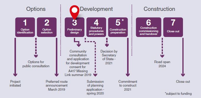
Under the Planning Act, a Development Consent Order (DCO) is the means of obtaining permission to construct and maintain developments categorised as Nationally Significant Infrastructure Projects (NSIPs). This includes energy, transport, water and waste projects. Some of our major road improvement proposals are classed as NSIPs. Before we submit a DCO application to the Planning Inspectorate, we hold consultations as part of our wider engagement activity. This is in addition to the request for representations and the examination of the application that the Planning Inspectorate organises once an application has been accepted.
For more information about how we follow the DCO process, please view our animation below:
What happens next
Once the consultation has closed at 11.59pm on Friday 8 November 2019, we’ll review all the suggestions and comments received during consultation.
We’ll take time to analyse and consider your feedback when making further refinements to the proposed design and to develop our planned mitigation measures.
We’ll set out a summary of the responses, and describe how our proposals have been informed and influenced by them, in a consultation report. This will form part of our DCO planning application and will also be available to the public following submission of the application. We expect to submit our DCO planning application by spring 2020 and, provided funding is granted, works would start in 2021.
In addition to this consultation process, we’ll continue to engage with anyone interested in, or impacted by, the scheme.
To help us shape the final design in preparation of our submission to the Planning Inspectorate, it is important you are involved now and submit your response by 11.59pm on Friday 8 November 2019.
Once we submit our application, the Planning Inspectorate (acting on behalf of the Secretary of State) may examine the application through written representation and public hearings during 2020, and then make a recommendation to the Secretary of State for Transport, who will decide on whether or not the scheme will go ahead. The process for this is explained below.
Audiences
- All members of the public
Interests
- Roads
Share
Share on Twitter Share on Facebook