
Lower Thames Crossing Consultation
Overview
We asked
We asked for feedback on proposals for a new road crossing connecting Kent and Essex, to relieve congestion at the Dartford Crossing and support economic growth.
You said
The Route Consultation received 47,034 responses, making it the largest ever public consultation for a UK road project.
We did
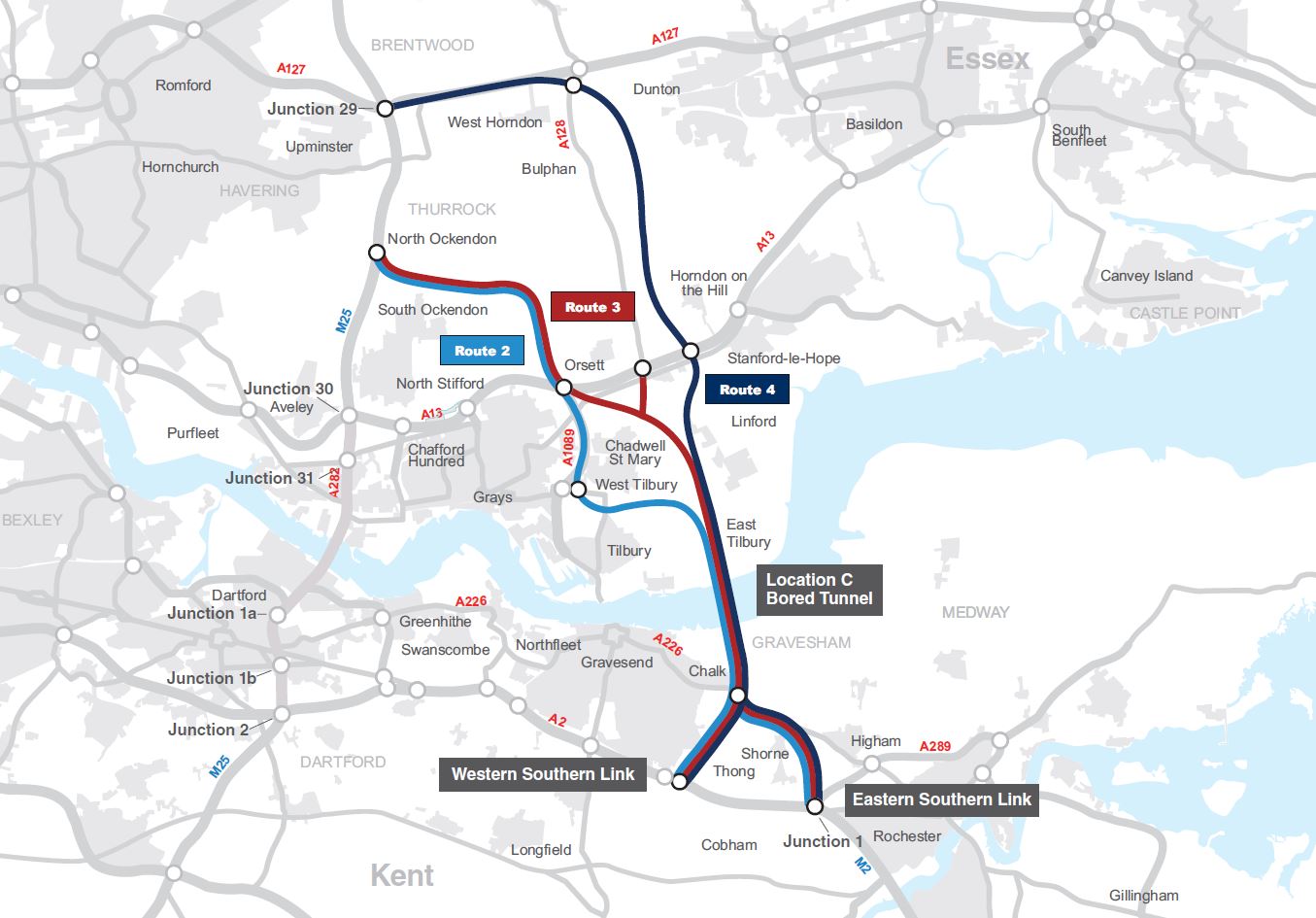
On 12 April 2017 the Secretary of State for Transport confirmed the preferred route for the Lower Thames Crossing. This is as follows:
- a bored tunnel crossing under the River Thames east of Gravesend and Tilbury (Location C)
- a new road north of the river which will join the M25 between junctions 29 and 30 (Route 3)
- a new road south of the river which will join the A2 east of Gravesend (the Western Southern Link)
The preferred route was carefully selected as the one that minimised community and environmental impacts as far as possible, whilst providing the transport and economic benefits of a modern, alternative crossing. This new 70mph, 13-mile route and crossing will be built to the highest safety standards using the latest in engineering and information technology.
To learn more about the preferred route, please see the documents below. For more information on the development of the project and to subscribe to our web alerts, please visit the Lower Thames Crossing webpage.
Post-consultation documents
You can view all post consultation documents in the related documents section below.
___________________________________________________________________________________
Update 25th March 2016
The consultation is now closed. Thank you for your response.
Your views will be taken into consideration before a decision on route and location is made by the Government, expected later this year.
Update ends
Highways England is consulting on proposals for a new road crossing of the River Thames connecting Kent and Essex. A new crossing is needed to reduce congestion at the existing Dartford crossing and unlock economic growth, supporting the development of new homes and jobs in the region.
There are important choices to be made and your views on the proposals presented here will inform the decision later this year on the route and crossing location.
Please take the time to read the supporting material, attend an event and provide us with your comments using our questionnaire.
Background
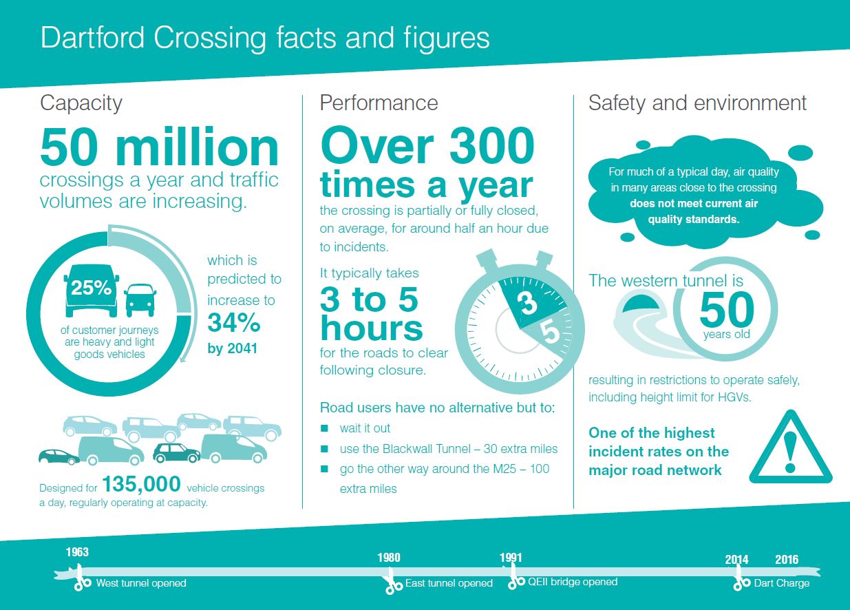
For over 50 years, the Dartford Crossing has provided the only road crossing of the Thames east of London. It is a critical part of the UK’s major road network carrying local, national and international traffic.
Congestion and closure of the existing crossing occurs frequently and this, together with a lack of alternative transport links, creates significant disruption and pollution. This impacts communities and businesses locally, regionally and elsewhere within the UK.
The removal of payment barriers and the introduction of electronic payments has recently improved traffic flow and journey times but does not address the need for increased capacity. Already carrying 50 million vehicles a year and with traffic volumes forecast to increase, the free flow improvements will only relieve congestion in the short-term and major improvements are needed to provide a long-lasting solution.
In addition to reducing delays for drivers, a new crossing could transform the region by providing a vital new connection across the Thames. It would stimulate economic growth by unlocking access to housing and job opportunities, and deliver benefits for generations to come. This would not only benefit the region but the whole of the UK, providing better journeys, enabling growth and building for the future.
A new crossing
Following a series of studies and a public consultation in 2013, the Government commissioned Highways England, the operator of the country’s motorways and major roads, to consider options at two locations. These are shown on the map overleaf, at the site of the current crossing, known as Location A, or a new crossing location further east, known as Location C.
At both locations we have developed engineering solutions and assessed them in terms of their economic, traffic, environmental and community impacts. The assessment has also taken into account the significant growth and development plans for the region. At Location C, three potential route options have been identified north of the river in Essex and two south of the river in Kent.
The purpose of this consultation
Having taken into account the existing conditions, the nature of the problems at Dartford and the needs and plans for the area, we are proposing a scheme which, in our view, best matches the objectives and balances the needs of road users, the community, the environment and business.
There are important choices to be made. Through this consultation we are inviting you to provide your views and comments on our proposals. Your views will be taken into consideration before a final decision is made by the Government later this year. Consultation closes on 24 March 2016.
We have developed three routes north of the river and two routes south of the river which meet the scheme objectives and on which we are seeking your views.
Have your say
This consultation is your opportunity to comment on our proposals. We will take your views into account as we finalise our recommendation to the Department for Transport.
To have your say about our proposal please fill in our consultation questionnaire. The questionnaire highlights the specific areas on which we are seeking you feedback, however you also have the opportunity to comment on any aspect of the proposals.
Consultation is taking place between 26 January and 24 March 2016 11:45pm.
Consultation Booklet and Summary Business Case
Factsheets
Biodiversity, Cultural Heritage and Landscape
Water, Air, Noise and Vibration
Minimising Construction Impacts
Property Booklets
Your Property and our Road Proposals
Big Maps
Detailed Maps
Scheme Assessment Report - Volume 3 Appendices Part 1 of 5
Scheme Assessment Report - Volume 3 Appendices Part 2 of 5
Scheme Assessment Report - Volume 3 Appendices Part 3 of 5
Scheme Assessment Report - Volume 3 Appendices Part 4 of 5
Scheme Assessment Report - Volume 3 Appendices Part 5 of 5
Join us at one of our events
We have organised a series of Public Information Events where members of our team will be on hand to answer your questions. All of the consultation documents will be available to view at those events. The event schedule is available here.
View the proposals
Copies of consultation materials, maps and questionnaires are available to view at a number of locations in your area. A list of the deposit locations is available here.
What happens next
Your responses to this consultation will be analysed and incorporated into our final recommendation to the Department for Transport. We are expecting Government to make an announcement later this year to confirm the route, location and type of crossing.
Audiences
- Anyone from any background
Interests
- Roads
Share
Share on Twitter Share on Facebook